IMAGES TAKEN NEAR TO
Fishermans Walk, LONDON, SE28 0HD
Introduction
This page details the photographs taken nearby to Fishermans Walk, SE28 0HD by members of the Geograph project.
The Geograph project started in 2005 with the aim of publishing, organising and preserving representative images for every square kilometre of Great Britain, Ireland and the Isle of Man.

There are currently over 7.5m images from over14,400 individuals and you can help contribute to the project by visiting https://www.geograph.org.uk
Image Map
Images are licensed for reuse under creativecommons.org/licenses/by-sa/2.0
Notes
- Clicking on the map will re-center to the selected point.
- The higher the marker number, the further away the image location is from the centre of the postcode.
Image Listing (79 Images Found)
Images are licensed for reuse under creativecommons.org/licenses/by-sa/2.0
Image
Details
Distance
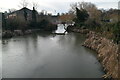
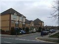
3
The canal at Thamesmead West
Thamesmead West was built from the 1990s onwards, and is a significant distance from the original development of Thamesmead from the late 1960s onwards. The landscaped canals here come from the time that this was part of Plumstead Marshes. This view is from a footbridge looking towards the bridge carrying Merbury Road over the canal. The view from the Merbury Road bridge can be seen at http://www.geograph.org.uk/photo/4391876
Image: © Marathon
Taken: 20 Mar 2015
0.04 miles
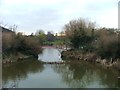
6
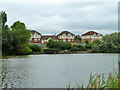
Housing by the water, Thamesmead
Not the Thames, but an artificial lake.
Image: © Robin Webster
Taken: 25 Jun 2011
0.06 miles
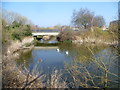
7
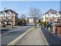
Merbury Road at Thamesmead West
Thamesmead West was built from the 1990s onwards, and is a significant distance from the original development of Thamesmead from the late 1960s onwards. The landscaped canals here come from the time that this was part of Plumstead Marshes.
This view looks along Merbury Road from the bridge seen at http://www.geograph.org.uk/photo/4391894
Image: © Marathon
Taken: 20 Mar 2015
0.06 miles
9
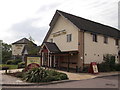
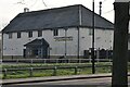
Princess Alice Public House, West Thamesmead
On the junction of the A2016 Western Way and Battery Road.
Part of the Crown Carveries chain.
Image: © David Anstiss
Taken: 21 Aug 2011
0.07 miles
10
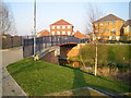
Thamesmead: Gallions Canal bridge
This bridge is designed to take cycle and foot traffic over the canal between Delisle Road and New Acres Road which is visible in the distance. For information about Gallions Canal see Image which was taken about 100 metres north of here.
Image: © Nigel Cox
Taken: 26 Mar 2007
0.07 miles