IMAGES TAKEN NEAR TO
Nathan Way, LONDON, SE28 0AQ
Introduction
This page details the photographs taken nearby to Nathan Way, SE28 0AQ by members of the Geograph project.
The Geograph project started in 2005 with the aim of publishing, organising and preserving representative images for every square kilometre of Great Britain, Ireland and the Isle of Man.

There are currently over 7.5m images from over14,400 individuals and you can help contribute to the project by visiting https://www.geograph.org.uk
Image Map
Images are licensed for reuse under creativecommons.org/licenses/by-sa/2.0
Notes
- Clicking on the map will re-center to the selected point.
- The higher the marker number, the further away the image location is from the centre of the postcode.
Image Listing (29 Images Found)
Images are licensed for reuse under creativecommons.org/licenses/by-sa/2.0
Image
Details
Distance
1
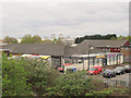
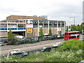
The Doric Centre, Kellner Road, Thamesmead
A number of businesses seem to be registered at this address as well as both Christian and Islamic organisations ("Sanctuary of Praise Ministries Place of Jubilation to Manifestation" and "AFWAS Islamic Centre" respectively).
Image: © Stephen Craven
Taken: 19 Apr 2015
0.07 miles
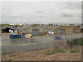
2
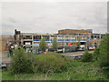
Former factory site off Nathan Way
There appears to have been an industrial building on this site at some time in the recent past.
Image: © Stephen Craven
Taken: 19 Apr 2015
0.08 miles
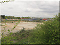
3
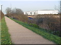
On the Ridgeway, Plumstead
The Ridgeway is a raised footpath from Plumstead station to Crossness which follows the embankment containing the Southern Outfall Sewer on its way to Crossness Sewage Treatment Works. It is seen here adjacent to Nathan Way.
Five years later the surface of the path had been substantially improved - http://www.geograph.org.uk/photo/4820773
Image: © Marathon
Taken: 8 Mar 2011
0.10 miles
4
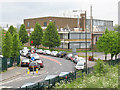
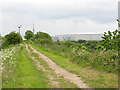
No way to calm traffic!
A lesson to any traffic engineers on here: whoever designed this particular bit of "traffic calming" didn't have his thinking cap on!
The theory is to use a road-narrowing island to force traffic through a single-lane width gap with signs giving priority to one direction. But this is on a blind bend, so the traffic that should give way cannot see whether there is anything coming from round the bend that has priority. As I discovered one very wet day when a car appeared round the bend just as I went through the gap, and went into an aquaplaning skid - a nasty accident was only just avoided.
Update: by 2015 the priority markings had been removed, perhaps for the reasons given above.
Image: © Stephen Craven
Taken: 9 May 2010
0.12 miles
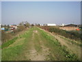
5
On the Ridgeway, Plumstead
The Ridgeway is a raised footpath from Plumstead station to Crossness which follows the embankment containing the Southern Outfall Sewer on its way to Crossness Sewage Treatment Works.
As can be seen in the photograph at http://www.geograph.org.uk/photo/2302099 taken five years earlier, the surface has been substantially improved.
Image: © Marathon
Taken: 9 Feb 2016
0.13 miles
6
The Ridgeway at Plumstead, looking north-east
Despite the rural sounding name, this "ridgeway" is no more than a footpath along the top of the embankment of London's southern outfall sewer. This view is along the embankment towards Crossness.
Image: © Stephen Craven
Taken: 9 May 2010
0.13 miles
7
Radiance Signs, Nathan Way
Radiance (signwriters) are one of several industrial premises along Nathan Way, Thamesmead.
There is also a banner on the building announcing that the Redeemed Christian Church of God meets there on Sundays - one of many African independent churches meeting in assorted hired premises in this part of London.
This bus is on route 472 (North Greenwich to Thamesmead).
Image: © Stephen Craven
Taken: 9 May 2010
0.15 miles
8
Auto Centres, Nathan Way, Thamesmead
Some of the business in this multi-occupancy building seem to have changed in the last five years, see Image
Image: © Stephen Craven
Taken: 19 Apr 2015
0.15 miles
9
Industrial units on Kellner Road, Thamesmead
At least one of these is occupied by Cembrit ("fibre cement based building materials for roofing and cladding.")
Image: © Stephen Craven
Taken: 19 Apr 2015
0.15 miles
