IMAGES TAKEN NEAR TO
Rommany Road, LONDON, SE27 9PT
Introduction
This page details the photographs taken nearby to Rommany Road, SE27 9PT by members of the Geograph project.
The Geograph project started in 2005 with the aim of publishing, organising and preserving representative images for every square kilometre of Great Britain, Ireland and the Isle of Man.

There are currently over 7.5m images from over14,400 individuals and you can help contribute to the project by visiting https://www.geograph.org.uk
Image Map
Images are licensed for reuse under creativecommons.org/licenses/by-sa/2.0
Notes
- Clicking on the map will re-center to the selected point.
- The higher the marker number, the further away the image location is from the centre of the postcode.
Image Listing (67 Images Found)
Images are licensed for reuse under creativecommons.org/licenses/by-sa/2.0
Image
Details
Distance
1
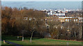
View from Norwood Park (2)
The park must offer one of the best panoramas in London. A plaque, sponsored by Network Rail and renewed in 2011 to commemorate the park's centenary, records that in 1986 the Greater London Council designated this a Protected Panoramic View. Vauxhall Tower (under construction) can just be made out above the trees. Other prominent landmarks vaguely discernible further right are Millbank Tower, London Telecom Tower (roughly central), Centre Point, London Eye, and the Shell Centre.
Broader view here: Image
Image: © Stephen Richards
Taken: 16 Dec 2012
0.05 miles
2
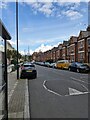
Gipsy Road
Gipsy Road looking east, the Crystal Palace Transmitter clearly visible in the distance.
Image: © PhotoMan9000
Taken: 4 May 2024
0.08 miles
3
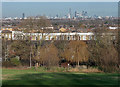
View from Norwood Park (3)
The park must offer one of the best panoramas in London. A plaque, sponsored by Network Rail and renewed in 2011 to commemorate the park's centenary, records that in 1986 the Greater London Council designated this a Protected Panoramic View. Strata, at Elephant and Castle, is the lone tower on the left while right of centre is the familiar profile of the Shard, the Gherkin and the burgeoning cluster of towers between them.
Broader view here: Image
Image: © Stephen Richards
Taken: 16 Dec 2012
0.09 miles
4
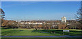
View from Norwood Park (1)
The park must offer one of the best panoramas in London. A plaque, sponsored by Network Rail and renewed in 2011 to commemorate the park's centenary, records that in 1986 the Greater London Council designated this a Protected Panoramic View. The view must encompass every prominent building in the capital from Vauxhall Tower (under construction) in the west to Canary Wharf in the east*. The latter's towers can just be made out on the far right, as can the central cluster in the City.
The tower in the foreground is Northwood House on Hamilton Road.
*The plaque records the following features: Millbank Tower, London Telecom Tower, Euston Centre, Victoria Tower, St Stephen's Tower, Centre Point, Highgate Ridge, Senate House, London Eye, Shell Centre, St John's Waterloo, Alexandra Palace, St Brides Fleet Street, Strata, St Paul's, St Mary le Bow, Guy's Hospital, Shard, Natwest Tower, Lloyd's of London, Heron Tower, Swiss Re Building, Christ Church Spitalfields, Tower Bridge, St Barnabas, St George in the East, Epping Forest, Dulwich College, Canary Wharf, and the HSBC Building.
Slightly more detailed views here: Image], Image] and Image
Image: © Stephen Richards
Taken: 16 Dec 2012
0.09 miles
5
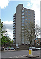
Northwood House, Hamilton Road
This is run by Lambeth Council as a sheltered housing scheme. Built by Lambeth, c1966.
Image: © Stephen Richards
Taken: 12 May 2012
0.10 miles
6
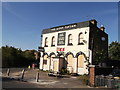
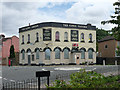
The Gipsy Tavern, West Norwood
Closed public house on the junction of Gipsy Road (in front) and Auckland Hill (on the left).
Image: © David Anstiss
Taken: 2 Oct 2011
0.13 miles
7
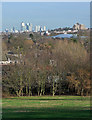
View from Norwood Park (4)
The park must offer one of the best panoramas in London. A plaque, sponsored by Network Rail and renewed in 2011 to commemorate the park's centenary, records that in 1986 the Greater London Council designated this a Protected Panoramic View. This is the easternmost section, showing the cluster of towers at Canary Wharf. I'm fairly sure the prominent block of flats further right is Dawson's Heights at Dulwich (Image]).
Broader view here: Image
Image: © Stephen Richards
Taken: 16 Dec 2012
0.13 miles
8
Kingswood junior and infants school (3)
Former Laundry Centre, now classrooms of the school on Gipsy Road.
Image: © David Anstiss
Taken: 2 Oct 2011
0.13 miles
9
Former Gipsy Tavern, Gipsy Road
The food lies rotting, the sports go unwatched and the garden is a wilderness. This particular pub may not have been much of a loss (I don't know, I never visited it), but there is something melancholic about every entry in the increasingly long catalogue of extinct pubs. I think this one went some time in 2011.
Image: © Stephen Richards
Taken: 9 Jun 2012
0.14 miles
10
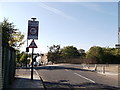
Gipsy Road Road bridge
This road leads from Gipsy Hill towards West Norwood.
It passes over the railway between West Norwood and Gipsy Hill.
Image: © David Anstiss
Taken: 2 Oct 2011
0.14 miles