IMAGES TAKEN NEAR TO
St. Julians Farm Road, LONDON, SE27 0RR
Introduction
This page details the photographs taken nearby to St. Julians Farm Road, SE27 0RR by members of the Geograph project.
The Geograph project started in 2005 with the aim of publishing, organising and preserving representative images for every square kilometre of Great Britain, Ireland and the Isle of Man.

There are currently over 7.5m images from over14,400 individuals and you can help contribute to the project by visiting https://www.geograph.org.uk
Image Map
Images are licensed for reuse under creativecommons.org/licenses/by-sa/2.0
Notes
- Clicking on the map will re-center to the selected point.
- The higher the marker number, the further away the image location is from the centre of the postcode.
Image Listing (64 Images Found)
Images are licensed for reuse under creativecommons.org/licenses/by-sa/2.0
Image
Details
Distance
1
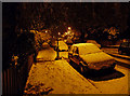
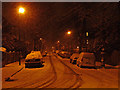
November snow, St Julian's Farm Road
Taken on the last day of the month, and only because I can't remember snow in London in November in the 22 years I've lived here (which is not to say it hasn't happened). It snowed most of the day in central London too, but didn't settle.
Image: © Stephen Richards
Taken: Unknown
0.03 miles
2
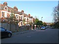
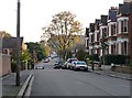
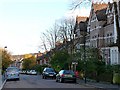
St Julian's Farm Road (2)
Looking east down St Julian's Farm Road from near the junction with Lamberhurst Road.
St Julian's Farm Road has several distinct stylistic groups of houses, all probably dating from the second half of the C19th (except for a few at the top end built in the 1920s/1930s).
The development of West Norwood began with the breaking up of Lord Thurlow's estate after his death in 1806, but it accelerated greatly with the arrival of the Crystal Palace railway in 1856; between 1851 and 1901 the population of the district of St. Luke's, Norwood increased from around 4,000 to around 36,000.
Image: © Stephen Richards
Taken: Unknown
0.04 miles
3
Thornlaw Road (2)
Looking west along the top end of Thornlaw Road, where it meets Lamberhurst Road, from near the junction with Thurlby Road.
These houses were probably built in the second half of the C19th.
The development of West Norwood began with the breaking up of Lord Thurlow's estate after his death in 1806, but it accelerated greatly with the arrival of the Crystal Palace railway in 1856; between 1851 and 1901 the population of the district of St. Luke's, Norwood increased from around 4,000 to around 36,000.
Image: © Stephen Richards
Taken: Unknown
0.05 miles
4
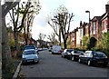
St Julian's Farm Road (5)
Looking west up St Julian's Farm Road from near the junction with Thurlby Road.
St Julian's Farm Road has several distinct stylistic groups of houses, all probably dating from the second half of the C19th (except for a few at the top end built in the 1920s/1930s).
The development of West Norwood began with the breaking up of Lord Thurlow's estate after his death in 1806, but it accelerated greatly with the arrival of the Crystal Palace railway in 1856; between 1851 and 1901 the population of the district of St. Luke's, Norwood increased from around 4,000 to around 36,000.
Image: © Stephen Richards
Taken: Unknown
0.05 miles
5
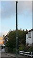
Stink pipe, St Julian's Farm Road
If I'd thought about this at all, I'd vaguely assumed it was an old street lamp, albeit without the lamp part. That is, until an internet search elicited the fact that this is probably one of the better surviving examples of a stink pipe, used to carry away noxious gases from the sewers. Despite its utterly unromantic function it is highly decorative with a crown at the top and a number of gilded bands. A plate at the bottom indicates that it was built by "J. Stone & Co, Engineers, Deptford, London SE".
A close-up of the base can be seen here: Image
Image: © Stephen Richards
Taken: Unknown
0.05 miles
6
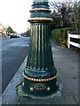
Detail of stink pipe, St Julian's Farm Road
The decorative base of the stink pipe at the top of the road. It shows that no structure was too humble for decoration to be lavished upon it.
A fuller view can be seen here: Image
Image: © Stephen Richards
Taken: Unknown
0.05 miles
7
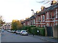
Lamberhurst Road
Looking south from the junction with St Julian's Farm Road. The houses in the foreground were probably built in the second half of the C19th, while the houses further down the road look as if they were built between the wars.
The development of West Norwood began with the breaking up of Lord Thurlow's estate after his death in 1806, but it accelerated greatly with the arrival of the Crystal Palace railway in 1856; between 1851 and 1901 the population of the district of St. Luke's, Norwood increased from around 4,000 to around 36,000.
Image: © Stephen Richards
Taken: Unknown
0.06 miles
8
St Julian's Farm Road (4)
Looking east down St Julian's Farm Road from near the junction with Uffington Road.
St Julian's Farm Road has several distinct stylistic groups of houses, all probably dating from the second half of the C19th (except for a few at the top end built in the 1920s/1930s), although the group on the right look as if they could date from the first or second decade of the C20th.
The development of West Norwood began with the breaking up of Lord Thurlow's estate after his death in 1806, but it accelerated greatly with the arrival of the Crystal Palace railway in 1856; between 1851 and 1901 the population of the district of St. Luke's, Norwood increased from around 4,000 to around 36,000.
Image: © Stephen Richards
Taken: Unknown
0.08 miles
9
Snow in Uffington Road
Seen during a most unusual third December snowfall (albeit a light one). See here for a similar, snow-less view: Image
Image: © Stephen Richards
Taken: 20 Dec 2010
0.08 miles
10
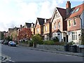
St Julian's Farm Road (3)
Looking east down St Julian's Farm Road from just past the junction with Lamberhurst Road.
St Julian's Farm Road has several distinct stylistic groups of houses, all probably dating from the second half of the C19th (except for a few at the top end built in the 1920s/1930s). The three houses on the right were built by George Francis Trollope, a local builder/developer, in around 1885.
The development of West Norwood began with the breaking up of Lord Thurlow's estate after his death in 1806, but it accelerated greatly with the arrival of the Crystal Palace railway in 1856; between 1851 and 1901 the population of the district of St. Luke's, Norwood increased from around 4,000 to around 36,000.
Image: © Stephen Richards
Taken: Unknown
0.08 miles