IMAGES TAKEN NEAR TO
Chichester Mews, LONDON, SE27 0NS
Introduction
This page details the photographs taken nearby to Chichester Mews, SE27 0NS by members of the Geograph project.
The Geograph project started in 2005 with the aim of publishing, organising and preserving representative images for every square kilometre of Great Britain, Ireland and the Isle of Man.

There are currently over 7.5m images from over14,400 individuals and you can help contribute to the project by visiting https://www.geograph.org.uk
Image Map
Images are licensed for reuse under creativecommons.org/licenses/by-sa/2.0
Notes
- Clicking on the map will re-center to the selected point.
- The higher the marker number, the further away the image location is from the centre of the postcode.
Image Listing (43 Images Found)
Images are licensed for reuse under creativecommons.org/licenses/by-sa/2.0
Image
Details
Distance
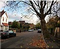
1
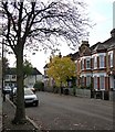
Thurlby Road (1)
Looking west along the short arm of the L-shaped Thurlby Road.
These houses were probably built in the second half of the C19th.
The development of West Norwood began with the breaking up of Lord Thurlow's estate after his death in 1806, but it accelerated greatly with the arrival of the Crystal Palace railway in 1856; between 1851 and 1901 the population of the district of St. Luke's, Norwood increased from around 4,000 to around 36,000.
The houses facing at the end are in Uffington Road, and look as if they were built between the wars.
Image: © Stephen Richards
Taken: Unknown
0.06 miles
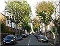
2
Thurlby Road (4)
Looking north along the long arm of the L-shaped Thurlby Road from near the junction with St Julian's Farm Road. This is pretty much the reverse of this view: Image
These houses were probably built in the second half of the C19th.
The development of West Norwood began with the breaking up of Lord Thurlow's estate after his death in 1806, but it accelerated greatly with the arrival of the Crystal Palace railway in 1856; between 1851 and 1901 the population of the district of St. Luke's, Norwood increased from around 4,000 to around 36,000.
Image: © Stephen Richards
Taken: Unknown
0.06 miles
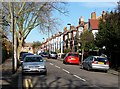
3
Uffington Road
Looking north along Uffington Road from the junction with St Julian's Farm Road.
Most of West Norwood was developed in Victorian and Edwardian times, but there is also a fair amount of housing from between the wars - the houses on the left look as if they were built during this period, while on the right are a couple of modern blocks.
Image: © Stephen Richards
Taken: Unknown
0.10 miles
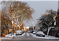
4
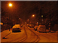
Snow in Uffington Road
Seen during a most unusual third December snowfall (albeit a light one). See here for a similar, snow-less view: Image
Image: © Stephen Richards
Taken: 20 Dec 2010
0.13 miles
6
Snow in Thurlby Road (1)
Seen after a most unusual second December snowfall. See here for a similar, snow-less view: Image
Image: © Stephen Richards
Taken: 20 Dec 2010
0.13 miles
7
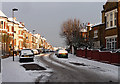
Snow in Thurlestone Road
Seen after a most unusual second December snowfall. These houses probably date from the second half of the C19th.
The development of West Norwood began with the breaking up of Lord Thurlow's estate after his death in 1806. Much of this initial phase has since been swept away by subsequent development which accelerated over the second half of the C19th and during the C20th, but there are pockets of houses surviving from the early days, mostly around Knight’s Hill, Norwood High Street/Elder Road and the area between them.
Image: © Stephen Richards
Taken: 20 Dec 2010
0.13 miles
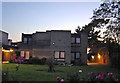
8
269 Leigham Court Road Flats
Winter December 2010
Image: © Deirdre Shaw
Taken: 2 Dec 2010
0.14 miles
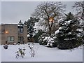
9
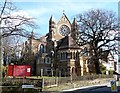
St Peter, Leigham Court Road
Built of polychromatic brick - rather fashionable at the time - in 1870 by R.W. Drew, with some later work by G.H. Fellowes Prynne in 1886-87. Grade II* listed.
Image: © Stephen Richards
Taken: Unknown
0.14 miles
10
Thurlby Road (2)
Looking south along the long arm of the L-shaped Thurlby Road, which is split into two by St Julian's Farm Road.
The development of West Norwood began with the breaking up of Lord Thurlow's estate after his death in 1806, but it accelerated greatly with the arrival of the Crystal Palace railway in 1856; between 1851 and 1901 the population of the district of St. Luke's, Norwood increased from around 4,000 to around 36,000.
Image: © Stephen Richards
Taken: Unknown
0.15 miles