IMAGES TAKEN NEAR TO
Rothschild Street, LONDON, SE27 0HQ
Introduction
This page details the photographs taken nearby to Rothschild Street, SE27 0HQ by members of the Geograph project.
The Geograph project started in 2005 with the aim of publishing, organising and preserving representative images for every square kilometre of Great Britain, Ireland and the Isle of Man.

There are currently over 7.5m images from over14,400 individuals and you can help contribute to the project by visiting https://www.geograph.org.uk
Image Map (Loading...)


Getting Data...Please wait
Leaflet Map data © OpenStreetMap
Images are licensed for reuse under creativecommons.org/licenses/by-sa/2.0
Notes
- Clicking on the map will re-center to the selected point.
- The higher the marker number, the further away the image location is from the centre of the postcode.
Image Listing (150 Images Found)
Images are licensed for reuse under creativecommons.org/licenses/by-sa/2.0
Image
Details
Distance
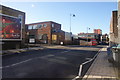
1
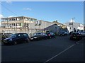
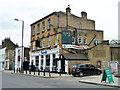
Mylands factory, Rothschild Street
Although primarily a residential area with a main shopping street, West Norwood also has an industrial area. Well, two streets to be precise. Mylands makes paints and polishes. According to their website, they are "the last manufacturer of decoration coatings based in the London area."
Rothschild Street was laid out c1900 on the site of some Huguenot almshouses.
Image: © Stephen Richards
Taken: Unknown
0.03 miles
2
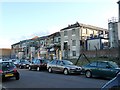
Winn and Coales factory, Rothschild Street
Although primarily a residential area with a main shopping street, West Norwood also has an industrial area. Well, two streets to be precise. Winn and Coales manufacture "corrosion and chemical resistant coatings and linings for the long term protection of steel and concrete."
Rothschild Street was laid out c1900 on the site of some Huguenot almshouses.
Image: © Stephen Richards
Taken: Unknown
0.04 miles
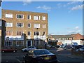
3
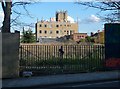
Offices, Chapel Road
An office block with an impressive array of aerials, antennae and other rooftop projections. Seen from Knight's Hill. Surprisingly, the empty plot of land shows no signs of development - surely there is space for several hundred "luxury" apartments.
Image: © Stephen Richards
Taken: Unknown
0.05 miles
4
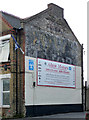
Ghost sign, Norwood High Street
A palimpsestic ghost sign? I think Kay's Motors is discernible, with at least one other later incumbent less so. The current ones, Alton Motors, may have painted over some of the original sign.
Image: © Stephen Richards
Taken: 6 Feb 2013
0.05 miles
5
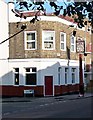
Formerly the Kings Head, Norwood High Street
Now Scandals, a bar and nightclub.
Image: © Robin Webster
Taken: 23 Jul 2011
0.05 miles
6
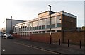
West Norwood Royal Mail Delivery Office, Windsor Grove
Built in 1962.
Image: © Jim Osley
Taken: 31 Oct 2015
0.06 miles
7
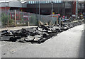
Road works, Ernest Avenue
The road by the bus station was in an awful state and was being broken up in preparation for re-surfacing.
Image: © Stephen Richards
Taken: 4 Aug 2013
0.06 miles
8
Former Bricklayers' Arms, Chapel Road
Another pub which has gone for a burton (or in this case a Charrington). Happily, the pub sign has survived even though it is in need of some TLC. The pub appears to have been converted to residential use.
Image: © Stephen Richards
Taken: Unknown
0.06 miles
9
Ernest Avenue, West Norwood
The road continues down to Norwood Garage on the left, which is the destination for many bus routes.
Image: © Bill Boaden
Taken: 1 Feb 2014
0.06 miles
10
Winn and Coales factory, Chapel Road
Although primarily a residential area with a main shopping street, West Norwood also has an industrial area. Well, two streets to be precise. Winn and Coales manufacture "corrosion and chemical resistant coatings and linings for the long term protection of steel and concrete."
Image: © Stephen Richards
Taken: Unknown
0.06 miles