IMAGES TAKEN NEAR TO
Cobden Mews, LONDON, SE26 6UX
Introduction
This page details the photographs taken nearby to Cobden Mews, SE26 6UX by members of the Geograph project.
The Geograph project started in 2005 with the aim of publishing, organising and preserving representative images for every square kilometre of Great Britain, Ireland and the Isle of Man.

There are currently over 7.5m images from over14,400 individuals and you can help contribute to the project by visiting https://www.geograph.org.uk
Image Map
Images are licensed for reuse under creativecommons.org/licenses/by-sa/2.0
Notes
- Clicking on the map will re-center to the selected point.
- The higher the marker number, the further away the image location is from the centre of the postcode.
Image Listing (91 Images Found)
Images are licensed for reuse under creativecommons.org/licenses/by-sa/2.0
Image
Details
Distance
1
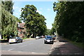
Crystal Palace: Sydenham Avenue
Looking north from Crystal Palace Park Road.
Image: © Dr Neil Clifton
Taken: 31 Aug 2012
0.04 miles
4
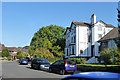
Houses on Lawrie Park Crescent SE26
The white semi-detached pair are original houses on the crescent. There were four or five of them. There were no houses on Border Road on the semi-circle of land between the roads, which was completely split up between gardens of houses on the crescent. All more recent houses have been built on parts of the original large plots.
Image: © Robin Webster
Taken: 1 Oct 2011
0.08 miles
5
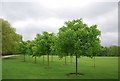
Young Chestnut trees, Crystal Palace Park
Image: © N Chadwick
Taken: 9 May 2010
0.09 miles
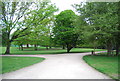
7
The Vale, Crystal Palace Park, winter afternoon
The Vale is an area of woodland and winding paths on the north side of Crystal Palace Park: the view here is looking out of the little side entrance onto Crystal Palace Park Road.
Image: © Christopher Hilton
Taken: 23 Dec 2011
0.10 miles
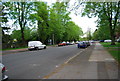
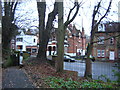
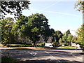
8
Border Tree
Looking along Border Road, and a border, towards an oak on a roundabout. The border between the London Boroughs of Lewisham and Bromley passes along Border Road, originally through the oak, but seems to have been slightly adjusted to include all of the roundabout in Bromley on the left. This border, which might have been that between Kent and London once, is not of very long standing, having been moved here from further south about 100 years ago.
Image: © Robin Webster
Taken: 1 Oct 2011
0.11 miles
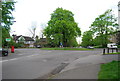
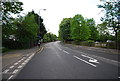
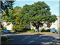
10
Roundabout on Border Road
Sydenham Avenue leads left towards Crystal Palace Park Road, and Lawrie Park Avenue leads right towards Westwood Hill.
Image: © David Anstiss
Taken: 2 Oct 2011
0.11 miles