IMAGES TAKEN NEAR TO
Ormanton Road, LONDON, SE26 6RG
Introduction
This page details the photographs taken nearby to Ormanton Road, SE26 6RG by members of the Geograph project.
The Geograph project started in 2005 with the aim of publishing, organising and preserving representative images for every square kilometre of Great Britain, Ireland and the Isle of Man.

There are currently over 7.5m images from over14,400 individuals and you can help contribute to the project by visiting https://www.geograph.org.uk
Image Map
Images are licensed for reuse under creativecommons.org/licenses/by-sa/2.0
Notes
- Clicking on the map will re-center to the selected point.
- The higher the marker number, the further away the image location is from the centre of the postcode.
Image Listing (96 Images Found)
Images are licensed for reuse under creativecommons.org/licenses/by-sa/2.0
Image
Details
Distance
7
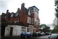
Large Victorian House, Charleville Circus
Image: © N Chadwick
Taken: 9 May 2010
0.07 miles
8
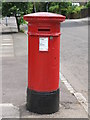
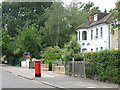
"Anonymous" (Victorian) postbox, Longton Avenue, SE26
The position of the posting aperture dates this postbox to 1883-87.
Image: © Mike Quinn
Taken: 4 Jul 2008
0.07 miles
9
Longton Avenue, SE26 (2)
Shows the location of Image
Image: © Mike Quinn
Taken: 4 Jul 2008
0.07 miles
10
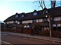
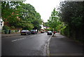
Houses on Westwood Hill, Upper Sydenham
On the northern edge of Crystal Palace
Image: © David Howard
Taken: 16 Feb 2014
0.07 miles