IMAGES TAKEN NEAR TO
Markwell Close, LONDON, SE26 6QF
Introduction
This page details the photographs taken nearby to Markwell Close, SE26 6QF by members of the Geograph project.
The Geograph project started in 2005 with the aim of publishing, organising and preserving representative images for every square kilometre of Great Britain, Ireland and the Isle of Man.

There are currently over 7.5m images from over14,400 individuals and you can help contribute to the project by visiting https://www.geograph.org.uk
Image Map
Images are licensed for reuse under creativecommons.org/licenses/by-sa/2.0
Notes
- Clicking on the map will re-center to the selected point.
- The higher the marker number, the further away the image location is from the centre of the postcode.
Image Listing (93 Images Found)
Images are licensed for reuse under creativecommons.org/licenses/by-sa/2.0
Image
Details
Distance
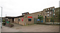
2
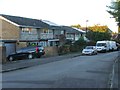
Westwood Hill, SE26 (A212)
The Crystal Palace TV transmitter dominates the area.
Image: © Robin Webster
Taken: 1 Oct 2011
0.09 miles
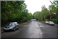
4
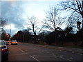
Westwood Hill, Upper Sydenham
Looking towards the Crystal Palace tower
Image: © David Howard
Taken: 16 Feb 2014
0.10 miles
5
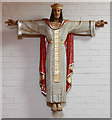
St Philip the Apostle, Wells Park Road - Statue
Christus Rex
Image: © John Salmon
Taken: 5 Feb 2011
0.11 miles
6
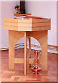
St Philip the Apostle, Wells Park Road - Font
Image: © John Salmon
Taken: 5 Feb 2011
0.11 miles
7
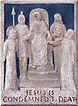
St Philip the Apostle, Wells Park Road - Station of the Cross
Jesus is condemned to death
Image: © John Salmon
Taken: 5 Feb 2011
0.11 miles
8
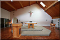
St Philip the Apostle, Wells Park Road - Chancel
Image: © John Salmon
Taken: 5 Feb 2011
0.11 miles