IMAGES TAKEN NEAR TO
Lawrie Park Avenue, LONDON, SE26 6HJ
Introduction
This page details the photographs taken nearby to Lawrie Park Avenue, SE26 6HJ by members of the Geograph project.
The Geograph project started in 2005 with the aim of publishing, organising and preserving representative images for every square kilometre of Great Britain, Ireland and the Isle of Man.

There are currently over 7.5m images from over14,400 individuals and you can help contribute to the project by visiting https://www.geograph.org.uk
Image Map
Images are licensed for reuse under creativecommons.org/licenses/by-sa/2.0
Notes
- Clicking on the map will re-center to the selected point.
- The higher the marker number, the further away the image location is from the centre of the postcode.
Image Listing (109 Images Found)
Images are licensed for reuse under creativecommons.org/licenses/by-sa/2.0
Image
Details
Distance
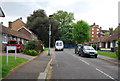
5
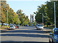
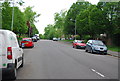
Lawrie Park Avenue, SE26
Looking towards St. Bartholomew's, Sydenham.
Image: © Robin Webster
Taken: 1 Oct 2011
0.06 miles
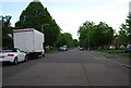
6
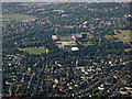
Sydenham from the air
Crystal Palace sports stadium is in the distance.
Image: © Thomas Nugent
Taken: 26 Aug 2019
0.07 miles
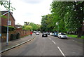
7
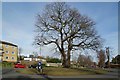
Oak Pollard in Sydenham Avenue
Taken looking towards Lawrie Park Ave
Image: © Glyn Baker
Taken: 8 Feb 2018
0.10 miles
9
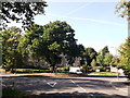
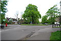
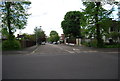
Roundabout on Border Road
Sydenham Avenue leads left towards Crystal Palace Park Road, and Lawrie Park Avenue leads right towards Westwood Hill.
Image: © David Anstiss
Taken: 2 Oct 2011
0.11 miles