IMAGES TAKEN NEAR TO
Hillmore Grove, LONDON, SE26 5RW
Introduction
This page details the photographs taken nearby to Hillmore Grove, SE26 5RW by members of the Geograph project.
The Geograph project started in 2005 with the aim of publishing, organising and preserving representative images for every square kilometre of Great Britain, Ireland and the Isle of Man.

There are currently over 7.5m images from over14,400 individuals and you can help contribute to the project by visiting https://www.geograph.org.uk
Image Map
Images are licensed for reuse under creativecommons.org/licenses/by-sa/2.0
Notes
- Clicking on the map will re-center to the selected point.
- The higher the marker number, the further away the image location is from the centre of the postcode.
Image Listing (59 Images Found)
Images are licensed for reuse under creativecommons.org/licenses/by-sa/2.0
Image
Details
Distance
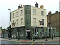
6
Sydenham Road, junction with Kent House Road
Image: © Stacey Harris
Taken: 6 Mar 2011
0.07 miles
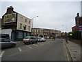
7
Sydenham Road entering the town centre
Kent House Road is ahead on the left
Image: © David Howard
Taken: 16 Feb 2014
0.08 miles
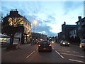
8
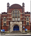
All Saints, Trewsbury, Road, Sydenham - Screen
Image: © John Salmon
Taken: 17 Nov 2011
0.08 miles
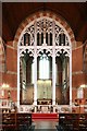
9
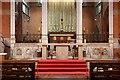
All Saints, Trewsbury, Road, Sydenham - Nave altar
Image: © John Salmon
Taken: 17 Nov 2011
0.08 miles
10
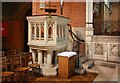
All Saints, Trewsbury, Road, Sydenham - Pulpit
Image: © John Salmon
Taken: 17 Nov 2011
0.08 miles