IMAGES TAKEN NEAR TO
Kent House Road, LONDON, SE26 5LP
Introduction
This page details the photographs taken nearby to Kent House Road, SE26 5LP by members of the Geograph project.
The Geograph project started in 2005 with the aim of publishing, organising and preserving representative images for every square kilometre of Great Britain, Ireland and the Isle of Man.

There are currently over 7.5m images from over14,400 individuals and you can help contribute to the project by visiting https://www.geograph.org.uk
Image Map
Images are licensed for reuse under creativecommons.org/licenses/by-sa/2.0
Notes
- Clicking on the map will re-center to the selected point.
- The higher the marker number, the further away the image location is from the centre of the postcode.
Image Listing (58 Images Found)
Images are licensed for reuse under creativecommons.org/licenses/by-sa/2.0
Image
Details
Distance
9
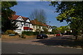
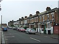
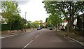
Woodbastwick Road, Sydenham
Woodbastwick Road takes its name from the Norfolk estate of the Cator family, local wealthy landowners based at Beckenham Place: they gave their name to Cator Road, off which Woodbastwick Road branches here, and the nearby Cator Park.
Image: © Christopher Hilton
Taken: 8 May 2016
0.18 miles
10
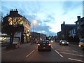
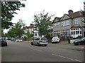
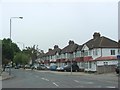
Sydenham Road entering the town centre
Kent House Road is ahead on the left
Image: © David Howard
Taken: 16 Feb 2014
0.18 miles