IMAGES TAKEN NEAR TO
Byne Road, LONDON, SE26 5JD
Introduction
This page details the photographs taken nearby to Byne Road, SE26 5JD by members of the Geograph project.
The Geograph project started in 2005 with the aim of publishing, organising and preserving representative images for every square kilometre of Great Britain, Ireland and the Isle of Man.

There are currently over 7.5m images from over14,400 individuals and you can help contribute to the project by visiting https://www.geograph.org.uk
Image Map
Images are licensed for reuse under creativecommons.org/licenses/by-sa/2.0
Notes
- Clicking on the map will re-center to the selected point.
- The higher the marker number, the further away the image location is from the centre of the postcode.
Image Listing (68 Images Found)
Images are licensed for reuse under creativecommons.org/licenses/by-sa/2.0
Image
Details
Distance
1
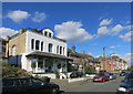
Venner Road, Sydenham
This one's a bit grander than the neighbours.
Image: © Des Blenkinsopp
Taken: 24 Feb 2016
0.07 miles
2
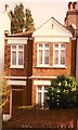
2002 Early Edwardian semi- detached house in Victorian street ,Wiverton Road, Sydenham SE26
This is 52 Wiverton Road in 2002. One of a pair in the centre of Wiverton Road, which is a road that runs parallel to Newlands Park Road, which is a main route linking Penge East Station to Sydenham High Street.
Image: © Hazel Greenfield
Taken: Unknown
0.07 miles
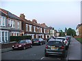
3
Studland Road, leading away from Alexandra Recreation Ground
Image: © Christopher Hilton
Taken: 8 May 2016
0.13 miles
4
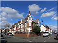
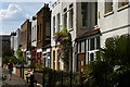
House on the Corner
An excuse for a bit of extra architectural exuberance.
This is on the junction of Byne and Venner Roads.
Image: © Des Blenkinsopp
Taken: 24 Feb 2016
0.15 miles
5
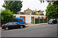
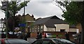
New Testament Church of God (Sydenham Branch)
A pentecostal church which appears to be meeting in a converted garage block.
Image: © Bill Boaden
Taken: 10 Oct 2015
0.15 miles
7
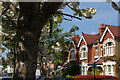
Tannsfield Road, Sydenham, in blossom season
Image: © Christopher Hilton
Taken: 8 May 2016
0.16 miles
8
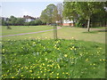
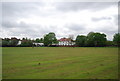
Alexandra Recreation Ground
Alexandra Recreation Ground was named after Queen Alexandra, King Edward VII’s wife, and was opened to the public in 1891 when she was Princess of Wales. Both the Green Chain Walk and the Capital Ring pass through it and anyone walking those routes will see the view here.
Image: © Marathon
Taken: 16 Apr 2011
0.17 miles
9
Kingdom Hall of Jehovah's Witness, Venner Rd
Image: © N Chadwick
Taken: 9 May 2010
0.18 miles