IMAGES TAKEN NEAR TO
Allendale Close, LONDON, SE26 5DX
Introduction
This page details the photographs taken nearby to Allendale Close, SE26 5DX by members of the Geograph project.
The Geograph project started in 2005 with the aim of publishing, organising and preserving representative images for every square kilometre of Great Britain, Ireland and the Isle of Man.

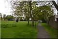
There are currently over 7.5m images from over14,400 individuals and you can help contribute to the project by visiting https://www.geograph.org.uk
Image Map
Images are licensed for reuse under creativecommons.org/licenses/by-sa/2.0
Notes
- Clicking on the map will re-center to the selected point.
- The higher the marker number, the further away the image location is from the centre of the postcode.
Image Listing (72 Images Found)
Images are licensed for reuse under creativecommons.org/licenses/by-sa/2.0
Image
Details
Distance
2
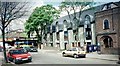
All Saints Court, Trewsbury Road
Picture taken shortly after conversion from church hall. A two bedroom flat here is currently advertised at £255,000. Photo scanned from an APS negative.
Image: © David Wright
Taken: 4 May 2001
0.06 miles
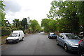
3
Capital Ring (and Green Chain Walk) between Alexandra Recreation Ground and Trewsbury Rd
Image: © N Chadwick
Taken: 9 May 2010
0.06 miles
4
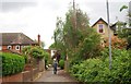
Boundary footpath, Trewsbury Road
This footpath off Trewsbury Road, Penge gives access to the northern end of the recreation ground Image It runs along the borough boundary between Lewisham (left) and Bromley (right), which suggests it may be a historic route.
Image: © Stephen Craven
Taken: 30 Aug 2008
0.07 miles
5
North side of Alexandra Recreation Ground
Taken from the combined Green Chain Walk / Capital Ring long distance path.
Image: © Christopher Hilton
Taken: 2 May 2016
0.08 miles
7
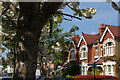
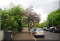
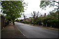
Tannsfield Road, Sydenham, in blossom season
Image: © Christopher Hilton
Taken: 8 May 2016
0.09 miles
8
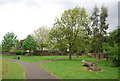
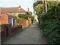
Path through Alexandra Recreation Ground
The route of the Capital Ring and Green Chain Walk.
Image: © N Chadwick
Taken: 9 May 2010
0.10 miles
10
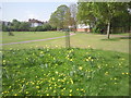
Alexandra Recreation Ground
Alexandra Recreation Ground was named after Queen Alexandra, King Edward VII’s wife, and was opened to the public in 1891 when she was Princess of Wales. Both the Green Chain Walk and the Capital Ring pass through it and anyone walking those routes will see the view here.
Image: © Marathon
Taken: 16 Apr 2011
0.10 miles