IMAGES TAKEN NEAR TO
Silverdale, LONDON, SE26 4SY
Introduction
This page details the photographs taken nearby to Silverdale, SE26 4SY by members of the Geograph project.
The Geograph project started in 2005 with the aim of publishing, organising and preserving representative images for every square kilometre of Great Britain, Ireland and the Isle of Man.

There are currently over 7.5m images from over14,400 individuals and you can help contribute to the project by visiting https://www.geograph.org.uk
Image Map
Images are licensed for reuse under creativecommons.org/licenses/by-sa/2.0
Notes
- Clicking on the map will re-center to the selected point.
- The higher the marker number, the further away the image location is from the centre of the postcode.
Image Listing (105 Images Found)
Images are licensed for reuse under creativecommons.org/licenses/by-sa/2.0
Image
Details
Distance
9
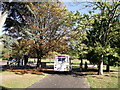
Ice Cream Van in Mayow Park
This van is providing welcome refreshment in the park.
Parked craftily near the children's play park and waiting for 'pester power' to supply customers.
Image: © David Anstiss
Taken: 2 Oct 2011
0.09 miles