IMAGES TAKEN NEAR TO
Dartmouth Road, LONDON, SE26 4RQ
Introduction
This page details the photographs taken nearby to Dartmouth Road, SE26 4RQ by members of the Geograph project.
The Geograph project started in 2005 with the aim of publishing, organising and preserving representative images for every square kilometre of Great Britain, Ireland and the Isle of Man.

There are currently over 7.5m images from over14,400 individuals and you can help contribute to the project by visiting https://www.geograph.org.uk
Image Map
Images are licensed for reuse under creativecommons.org/licenses/by-sa/2.0
Notes
- Clicking on the map will re-center to the selected point.
- The higher the marker number, the further away the image location is from the centre of the postcode.
Image Listing (31 Images Found)
Images are licensed for reuse under creativecommons.org/licenses/by-sa/2.0
Image
Details
Distance
1
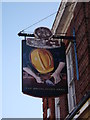
The Bricklayers Arms, Pub Sign, Upper Sydenham
On the side of Image On Kirkdale.
Image: © David Anstiss
Taken: 2 Oct 2011
0.06 miles
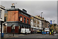
2
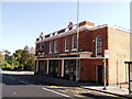
The Bricklayers Arms, Public House, Upper Sydenham
Pub on the junction of the A2216 Dartmouth Road (in front) and Sydenham Park Road (behind the pub).
Image: © David Anstiss
Taken: 2 Oct 2011
0.06 miles
4
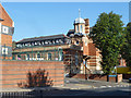
Holy Trinity Primary School, Forest Hill
Grade II listed school on Dartmouth Road.
See http://www.britishlistedbuildings.co.uk/en-462528-holy-trinity-school-lewisham for more details about the school.
Image: © David Anstiss
Taken: 2 Oct 2011
0.15 miles
5
Sydenham
Shops and offices on the junction of Kirkgate with Dartmouth Road (out of picture, to the right).
Image: © Peter Trimming
Taken: 24 Nov 2016
0.16 miles
6
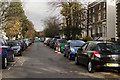
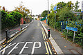
Sydenham
Sydenham Park. This is probably a busy cut-through, but the road was closed due to pavement works.
Image: © Peter Trimming
Taken: 24 Nov 2016
0.16 miles
7
A Remnant of Old Sydenham
These weatherboarded cottages in Kirkdale, near the junction with Dartmouth Road are a rare survival. Photo taken about 1975 and scanned from old slide.
Image: © David Wright
Taken: Unknown
0.17 miles
8
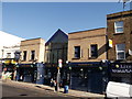
The Windmill, Public House, Upper Sydenham
On the A2216 Kirkdale.
Image: © David Anstiss
Taken: 2 Oct 2011
0.17 miles
9
Dartmouth Road Library, Forest Hill
A grade II listed building, of 1900 according to the citation, but with 1901 appearing on the front.
Image: © Robin Webster
Taken: 1 Oct 2011
0.17 miles
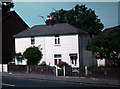
10
Kelvin Grove
A narrow residential road on the eastern side of Sydenham Hill.
Image: © Bill Boaden
Taken: 10 Oct 2015
0.17 miles