IMAGES TAKEN NEAR TO
Round Hill, LONDON, SE26 4RF
Introduction
This page details the photographs taken nearby to Round Hill, SE26 4RF by members of the Geograph project.
The Geograph project started in 2005 with the aim of publishing, organising and preserving representative images for every square kilometre of Great Britain, Ireland and the Isle of Man.

There are currently over 7.5m images from over14,400 individuals and you can help contribute to the project by visiting https://www.geograph.org.uk
Image Map
Images are licensed for reuse under creativecommons.org/licenses/by-sa/2.0
Notes
- Clicking on the map will re-center to the selected point.
- The higher the marker number, the further away the image location is from the centre of the postcode.
Image Listing (21 Images Found)
Images are licensed for reuse under creativecommons.org/licenses/by-sa/2.0
Image
Details
Distance
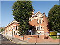
1
Holy Trinity Primary School, Forest Hill
Grade II listed school on Dartmouth Road.
See http://www.britishlistedbuildings.co.uk/en-462528-holy-trinity-school-lewisham for more details about the school.
Image: © David Anstiss
Taken: 2 Oct 2011
0.10 miles
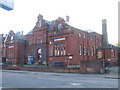
2
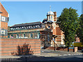
Dartmouth Road Library, Forest Hill
A grade II listed building, of 1900 according to the citation, but with 1901 appearing on the front.
Image: © Robin Webster
Taken: 1 Oct 2011
0.11 miles
3
Forest Hill Public Library
Grade II listed building on the junction of the A2216 Dartmouth Road (in front) and Thropewood Road (on the left).
See http://www.britishlistedbuildings.co.uk/en-436183-forest-hill-public-library-lewisham for more details about the library.
Image: © David Anstiss
Taken: 2 Oct 2011
0.12 miles
5
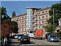
McLeod House, SE23
One of several similar blocks of flats here.
Image: © Robin Webster
Taken: 1 Oct 2011
0.14 miles
6
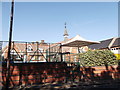
Forest Hill swimming baths
Due for rebuilding, the frontage is to be retained following a local campaign.
Image: © Malc McDonald
Taken: 4 Apr 2010
0.15 miles
7
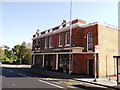
The Bricklayers Arms, Public House, Upper Sydenham
Pub on the junction of the A2216 Dartmouth Road (in front) and Sydenham Park Road (behind the pub).
Image: © David Anstiss
Taken: 2 Oct 2011
0.15 miles
8
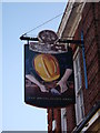
The Bricklayers Arms, Pub Sign, Upper Sydenham
On the side of Image On Kirkdale.
Image: © David Anstiss
Taken: 2 Oct 2011
0.15 miles
9
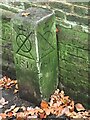
Boundary marker
A boundary stone on the footpath connecting Kirkdale with Lammas Green Estate. It marks land owned the Bridge House charity, established in 1282 by the City of London. Lammas Green Estate is owned by the City but located in the London Borough of Lewisham.
Image: © Brian Whittle
Taken: 10 Nov 2020
0.19 miles
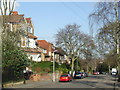
10
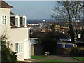
Lammas Green view
View looking southeastwards from Lammas Green
Image: © Malc McDonald
Taken: 4 Apr 2010
0.21 miles