IMAGES TAKEN NEAR TO
Lewisham, LONDON, SE26 4PR
Introduction
This page details the photographs taken nearby to SE26 4PR by members of the Geograph project.
The Geograph project started in 2005 with the aim of publishing, organising and preserving representative images for every square kilometre of Great Britain, Ireland and the Isle of Man.

There are currently over 7.5m images from over14,400 individuals and you can help contribute to the project by visiting https://www.geograph.org.uk
Image Map
Images are licensed for reuse under creativecommons.org/licenses/by-sa/2.0
Notes
- Clicking on the map will re-center to the selected point.
- The higher the marker number, the further away the image location is from the centre of the postcode.
Image Listing (144 Images Found)
Images are licensed for reuse under creativecommons.org/licenses/by-sa/2.0
Image
Details
Distance
1
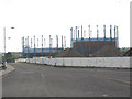
Bell Green Redevelopment Phase 2 (B)
The Crystal Palace District Gas Company was formed in 1854 principally as a result of the development around the Crystal Palace. The works ceased gas production in 1969, and the site is at last being redeveloped for leisure, retail and housing though the gas holders remain.
Image: © Stephen Craven
Taken: 8 Jun 2008
0.02 miles
2
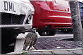
Why does a starling lift up one leg?
Because if it lifted them both up, it would fall over.
One of many starlings seen in the Bell Green Retail Park.
Image: © Peter Trimming
Taken: 30 Aug 2018
0.04 miles
3

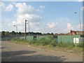
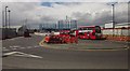
Bus Turnaround at Bell Green
Part of a new retail park on the site of an old gas works.
Image: © Des Blenkinsopp
Taken: 9 Aug 2016
0.04 miles
4
Bell Green Redevelopment Phase 2 (A)
The former gasworks site is being redeveloped: Phase 1 was the Sainsbury supermarket (see TQ3671) and phase 2 will be housing and leisure facilities.
Image: © Stephen Craven
Taken: 8 Jun 2008
0.04 miles
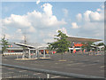
5
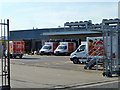
Sainsbury's yard, Bell Green
The near bays appear to be devoted to their home delivery service.
Image: © Robin Webster
Taken: 1 Oct 2011
0.06 miles
6
Bus turnaround, Bell Green
With barriers that have been, or will be, used in roadworks associated with the major redevelopment that's been taking place at Bell Green recently. In the background are the twin gasholders of Image On the left is Sainsbury's. On the right, not yet mapped, are new retail, warehousing, storage and office units mentioned at http://councilmeetings.lewisham.gov.uk/documents/s13023/Land%20at%20the%20Former%20Bell%20Green%20Gas%20Works%20Bell%20Green%20SE26.pdf and I think named Trade City Sydenham.
Image: © Derek Harper
Taken: 9 May 2013
0.06 miles
7
Sydenham Sainsbury's after hours
The deserted car park of the Sainsbury's hypermarket at 6pm on Sunday.
Image: © Stephen Craven
Taken: 8 Jun 2008
0.08 miles
8
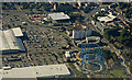
Bell Green retail park from the air
Ground works are in progress at the disused gas holders on the right.
Image: © Thomas Nugent
Taken: 26 Aug 2019
0.08 miles
9
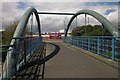
Bridge over Pool River
The bridge shown at http://www.geograph.org.uk/search.php?i=41479628 , with, in the background, the bus turnaround shown in Image
Image: © Derek Harper
Taken: 9 May 2013
0.10 miles
10
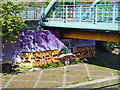
High quality graffiti, Bell Green
Remarkably well executed under the bridge over the Pool River. All that can be seen of the text from this angle is 'AERO CEN', the rest being hidden round the angle of the abutment. So it might be 'AERO CENT' (balanced) or 'AERO CENTRE' (lopsided) or of course something else. Have a look in close-up.
Image: © Robin Webster
Taken: 1 Oct 2011
0.10 miles