IMAGES TAKEN NEAR TO
Kingsthorpe Road, LONDON, SE26 4PG
Introduction
This page details the photographs taken nearby to Kingsthorpe Road, SE26 4PG by members of the Geograph project.
The Geograph project started in 2005 with the aim of publishing, organising and preserving representative images for every square kilometre of Great Britain, Ireland and the Isle of Man.

There are currently over 7.5m images from over14,400 individuals and you can help contribute to the project by visiting https://www.geograph.org.uk
Image Map
Images are licensed for reuse under creativecommons.org/licenses/by-sa/2.0
Notes
- Clicking on the map will re-center to the selected point.
- The higher the marker number, the further away the image location is from the centre of the postcode.
Image Listing (118 Images Found)
Images are licensed for reuse under creativecommons.org/licenses/by-sa/2.0
Image
Details
Distance
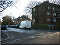
3
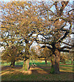
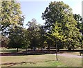
Mayow Park (1)
Venerable oaks, still partially clothed on the last day of November after an exceptionally mild autumn.
Image: © Stephen Richards
Taken: 30 Nov 2014
0.12 miles
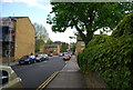
5
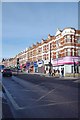
A212 Sydenham Rd
At the junction with Mayow Rd
Image: © Glyn Baker
Taken: 8 Feb 2018
0.13 miles
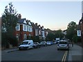
6
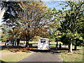
Ice Cream Van in Mayow Park
This van is providing welcome refreshment in the park.
Parked craftily near the children's play park and waiting for 'pester power' to supply customers.
Image: © David Anstiss
Taken: 2 Oct 2011
0.13 miles
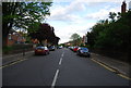
7
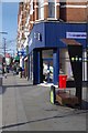
Modern Times in Sydenham
A piece of street furniture that would have been unknown at the start of the Geograph Project in 2005, a free WiFi hot spot and charging station. At that time those in the know used secret chalk marks to indicate where one could detect an unsecure private network.
Image: © Glyn Baker
Taken: 8 Feb 2018
0.13 miles
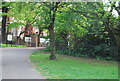
8
Path in Mayow Park
This central tree lined path leads towards the tennis courts and Mayow Road.
Image: © David Anstiss
Taken: 2 Oct 2011
0.13 miles