IMAGES TAKEN NEAR TO
Sydenham Park Road, LONDON, SE26 4LP
Introduction
This page details the photographs taken nearby to Sydenham Park Road, SE26 4LP by members of the Geograph project.
The Geograph project started in 2005 with the aim of publishing, organising and preserving representative images for every square kilometre of Great Britain, Ireland and the Isle of Man.

There are currently over 7.5m images from over14,400 individuals and you can help contribute to the project by visiting https://www.geograph.org.uk
Image Map
Images are licensed for reuse under creativecommons.org/licenses/by-sa/2.0
Notes
- Clicking on the map will re-center to the selected point.
- The higher the marker number, the further away the image location is from the centre of the postcode.
Image Listing (43 Images Found)
Images are licensed for reuse under creativecommons.org/licenses/by-sa/2.0
Image
Details
Distance
1
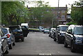
Sydenham Park Road
Dropping down to a dip on it way to meet the A2216. The sun is playing tricks on this windy day - no sooner has it come out than it's gone in again.
Image: © Derek Harper
Taken: 9 May 2013
0.06 miles
2
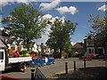
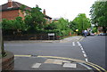
Roadworks on Peak Hill, Sydenham
At the junction with Sydenham Park Road.
Image: © Derek Harper
Taken: 9 May 2013
0.09 miles
3
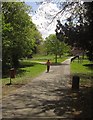
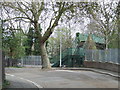
Mayow Park
A jogger enters the park http://www.lewisham.gov.uk/inmyarea/openspaces/parks/Pages/mayow-park.aspx from the Silverdale entrance. See also http://www.geograph.org.uk/search.php?i=41466593 for other images.
Image: © Derek Harper
Taken: 9 May 2013
0.14 miles
4
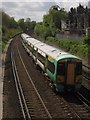
Train near Sydenham
An Electrostar EMU passes beneath the footbridge from which Image] was taken, looking in the opposite direction. On the right is an electricity sub-station.
Image: © Derek Harper
Taken: 9 May 2013
0.15 miles
5
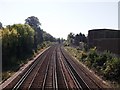
Railway line to Sydenham
As seen from a footbridge between Sydenham Park and Dacres Road.
This line leads from Forest Hill.
Image: © David Anstiss
Taken: 2 Oct 2011
0.15 miles
6
Sydenham Park, SE26
Sydenham Park is a no-through-road, which ends at a railway. Pedestrians can cross the tracks using the footbridge.
Image: © Malc McDonald
Taken: 3 Apr 2011
0.16 miles
7
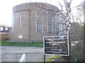
Dietrich Bonhoeffer Kirche
German church in Forest Hill
Image: © Malc McDonald
Taken: 4 Apr 2010
0.17 miles