IMAGES TAKEN NEAR TO
Mayow Road, LONDON, SE26 4JA
Introduction
This page details the photographs taken nearby to Mayow Road, SE26 4JA by members of the Geograph project.
The Geograph project started in 2005 with the aim of publishing, organising and preserving representative images for every square kilometre of Great Britain, Ireland and the Isle of Man.

There are currently over 7.5m images from over14,400 individuals and you can help contribute to the project by visiting https://www.geograph.org.uk
Image Map
Images are licensed for reuse under creativecommons.org/licenses/by-sa/2.0
Notes
- Clicking on the map will re-center to the selected point.
- The higher the marker number, the further away the image location is from the centre of the postcode.
Image Listing (78 Images Found)
Images are licensed for reuse under creativecommons.org/licenses/by-sa/2.0
Image
Details
Distance
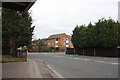
1
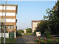
Hazel Grove flats, Sydenham
These flats appear to be in good condition, but they are apparently a crime hot-spot.
Image: © Stephen Craven
Taken: 30 Aug 2008
0.06 miles
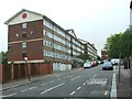
2
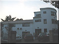
Crown Court, Berryman's Lane, Sydenham
Despite the name this is not a legal institution, just a recent housing development - a mixture of houses to buy and flats for rent.
Image: © Stephen Craven
Taken: 30 Aug 2008
0.09 miles