IMAGES TAKEN NEAR TO
Wrights Road, LONDON, SE25 6RX
Introduction
This page details the photographs taken nearby to Wrights Road, SE25 6RX by members of the Geograph project.
The Geograph project started in 2005 with the aim of publishing, organising and preserving representative images for every square kilometre of Great Britain, Ireland and the Isle of Man.

There are currently over 7.5m images from over14,400 individuals and you can help contribute to the project by visiting https://www.geograph.org.uk
Image Map
Images are licensed for reuse under creativecommons.org/licenses/by-sa/2.0
Notes
- Clicking on the map will re-center to the selected point.
- The higher the marker number, the further away the image location is from the centre of the postcode.
Image Listing (39 Images Found)
Images are licensed for reuse under creativecommons.org/licenses/by-sa/2.0
Image
Details
Distance
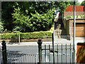
1
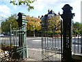
Gates to Grangewood Park
Grangewood was originally part of the Manor of Whitehorse and the wood known as Whitehorse Wood was part of the Great North Wood. In 1800 the wood was completely surrounded by fields but by the mid 19th century the east and west sides of Whitehorse Wood were cleared for development, whilst the remaining 30 acres to the east of Grange Road were developed as a private estate. This now forms Grangewood Park. It had a mansion at the centre with extensive gardens to the south. Croydon Corporation bought Grangewood Park in 1900. The mansion and grounds were badly damaged in the Second World War and the house was demolished in 1960. The formal garden at the centre of the park marks the site. When the Council acquired the park they built a bandstand but this was also demolished after the Second World War. Much of the park is what is called woodland park which is not as dense as ordinary woodland. These gates lead out to Ross Road at its junction with Wharncliffe Road and Canham Road. The house opposite is in the continuation of Ross Road.
Image: © Marathon
Taken: 21 Oct 2011
0.07 miles
2
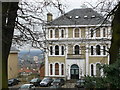
House in Ross Road
This imposing house, high on the hill, can be seen be seen from several (distant) photographic points. Severely damaged by fire in the late 20th century, it has been restored to its former glory. Photographed from inside Grangewood Park.
Image: © Peter Trimming
Taken: 28 Feb 2009
0.08 miles
3
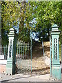
Entrance to Grangewood Park
Grangewood was originally part of the Manor of Whitehorse and the wood known as Whitehorse Wood was part of the Great North Wood. In 1800 the wood was completely surrounded by fields but by the mid 19th century the east and west sides of Whitehorse Wood were cleared for development, whilst the remaining 30 acres to the east of Grange Road were developed as a private estate. This now forms Grangewood Park. It had a mansion at the centre with extensive gardens to the south. Croydon Corporation bought Grangewood Park in 1900. The mansion and grounds were badly damaged in the Second World War and the house was demolished in 1960. The formal garden at the centre of the park marks the site. When the Council acquired the park they built a bandstand but this was also demolished after the Second World War. Much of the park is what is called woodland park which is not as dense as ordinary woodland. These gates lead into the park from Ross Road near its junction with Wharncliffe Road and Canham Road.
Image: © Marathon
Taken: 21 Oct 2011
0.08 miles
4
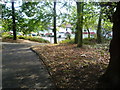
Exit from Grangewood Park
Grangewood was originally part of the Manor of Whitehorse and the wood known as Whitehorse Wood was part of the Great North Wood. In 1800 the wood was completely surrounded by fields but by the mid 19th century the east and west sides of Whitehorse Wood were cleared for development, whilst the remaining 30 acres to the east of Grange Road were developed as a private estate. This now forms Grangewood Park. It had a mansion at the centre with extensive gardens to the south. Croydon Corporation bought Grangewood Park in 1900. The mansion and grounds were badly damaged in the Second World War and the house was demolished in 1960. The formal garden at the centre of the park marks the site. When the Council acquired the park they built a bandstand but this was also demolished after the Second World War. Much of the park is what is called woodland park which is not as dense as ordinary woodland. The path leads down to Ross Road which is on the right here.
Image: © Marathon
Taken: 21 Oct 2011
0.08 miles
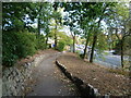
5
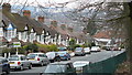
Houses in Ross Road
The steep streets in this area can be clearly seen in this photograph. The gradient on Ross Road is by no means the steepest! Central Croydon can be seen in the distance.
Image: © Peter Trimming
Taken: 28 Feb 2009
0.11 miles
6
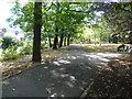
An entrance to Grangewood Park
Grangewood was originally part of the Manor of Whitehorse and the wood known as Whitehorse Wood was part of the Great North Wood. In 1800 the wood was completely surrounded by fields but by the mid 19th century the east and west sides of Whitehorse Wood were cleared for development, whilst the remaining 30 acres to the east of Grange Road were developed as a private estate. This now forms Grangewood Park. It had a mansion at the centre with extensive gardens to the south. Croydon Corporation bought Grangewood Park in 1900. The mansion and grounds were badly damaged in the Second World War and the house was demolished in 1960. The formal garden at the centre of the park marks the site. When the Council acquired the park they built a bandstand but this was also demolished after the Second World War. Much of the park is what is called woodland park which is not as dense as ordinary woodland. The path leads down to Ross Road.
Image: © Marathon
Taken: 21 Oct 2011
0.13 miles
7
Grangewood Park alongside Ross Road
Grangewood was originally part of the Manor of Whitehorse and the wood known as Whitehorse Wood was part of the Great North Wood. In 1800 the wood was completely surrounded by fields but by the mid 19th century the east and west sides of Whitehorse Wood were cleared for development, whilst the remaining 30 acres to the east of Grange Road were developed as a private estate. This now forms Grangewood Park. It had a mansion at the centre with extensive gardens to the south. Croydon Corporation bought Grangewood Park in 1900. The mansion and grounds were badly damaged in the Second World War and the house was demolished in 1960. The formal garden at the centre of the park marks the site. When the Council acquired the park they built a bandstand but this was also demolished after the Second World War. Much of the park is what is called woodland park which is not as dense as ordinary woodland. The path leads down to Ross Road which is on the left here.
Image: © Marathon
Taken: 21 Oct 2011
0.14 miles
8
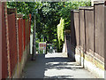
Footpath 680 to Wharncliffe Gardens
Looking across Wharncliffe Road from Grangewood Park. The steps form a large part of the path.
Image: © Robin Webster
Taken: 1 Jul 2011
0.14 miles
9
Wharncliffe Road, SE19: footpath to Wharncliffe Gardens
Image: © Christopher Hilton
Taken: 18 Sep 2012
0.14 miles
10
Footpath 680 from Wharncliffe Gardens to Wharncliffe Road
A large part of this short path is steps. It reaches the lower road opposite an entrance to Grangewood Park.
Image: © Robin Webster
Taken: 1 Jul 2011
0.15 miles