IMAGES TAKEN NEAR TO
Dunkeld Road, LONDON, SE25 6QH
Introduction
This page details the photographs taken nearby to Dunkeld Road, SE25 6QH by members of the Geograph project.
The Geograph project started in 2005 with the aim of publishing, organising and preserving representative images for every square kilometre of Great Britain, Ireland and the Isle of Man.

There are currently over 7.5m images from over14,400 individuals and you can help contribute to the project by visiting https://www.geograph.org.uk
Image Map
Images are licensed for reuse under creativecommons.org/licenses/by-sa/2.0
Notes
- Clicking on the map will re-center to the selected point.
- The higher the marker number, the further away the image location is from the centre of the postcode.
Image Listing (89 Images Found)
Images are licensed for reuse under creativecommons.org/licenses/by-sa/2.0
Image
Details
Distance
1
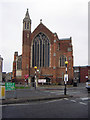
St Alban (The Martyr) Church
Situation at the end of Grange Road, front facing to Whitehorse Lane.
Image: © Chris L L
Taken: 27 Dec 2008
0.05 miles
2
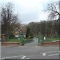
Grangewood Park
The southern entrance to Grangewood Park from Ross Road
Image: © Jon Bryant
Taken: 18 Mar 2006
0.06 miles
3
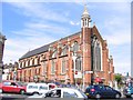
St Alban's church, Grange Road
Anglican church, listed grade II. The first church designed by the late Victorian architect Sir Ninian Comper. It is situated on the busy junction of Grange Road and the High Street.
Image: © Stephen Craven
Taken: 25 May 2005
0.06 miles
4
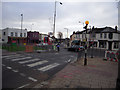
Junction of Thornton Heath High Street, Grange Road & Whitehorse Lane
End of Grange Road, where it meets with Thornton Heath. One way road at this point, cannot enter from High Street.
Image: © Chris L L
Taken: 27 Dec 2008
0.06 miles
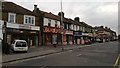
5
Launderette, Whitehorse Lane, Thornton Heath
Image: © Christopher Hilton
Taken: 28 Sep 2011
0.07 miles
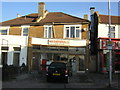
6
Shops at junction of Thirsk Road and Whitehorse Lane, Thornton Heath
Image: © Christopher Hilton
Taken: 28 Sep 2011
0.07 miles
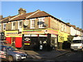
7
Launderette and shops, Whitehorse Lane, Thornton Heath
Image: © Christopher Hilton
Taken: 11 Sep 2013
0.08 miles
8

Access road behind shops, north side of Thornton Heath High Street
Walk this way often enough, and you wonder if everyone in Thornton Heath sleeps on bare boards; either that, or people drive across London to dump mattresses round here.
Image: © Christopher Hilton
Taken: 13 Sep 2011
0.08 miles
9
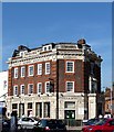
Prince George, High Street
A typical pub of the former Truman Hanbury Buxton Brewery. Built of brick and faience, probably some time between the wars and possibly designed by A.E. Sewell.
The brewery dates back to the late C17th, and it finally closed in 1988 although many of its pubs are intact (e.g.: Image).
Image: © Stephen Richards
Taken: Unknown
0.08 miles
10
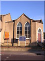
Clifton Gospel Hall, Whitehorse Lane, Thornton Heath
Image: © Christopher Hilton
Taken: 28 Sep 2011
0.08 miles