IMAGES TAKEN NEAR TO
Selhurst Road, LONDON, SE25 6LU
Introduction
This page details the photographs taken nearby to Selhurst Road, SE25 6LU by members of the Geograph project.
The Geograph project started in 2005 with the aim of publishing, organising and preserving representative images for every square kilometre of Great Britain, Ireland and the Isle of Man.

There are currently over 7.5m images from over14,400 individuals and you can help contribute to the project by visiting https://www.geograph.org.uk
Image Map
Images are licensed for reuse under creativecommons.org/licenses/by-sa/2.0
Notes
- Clicking on the map will re-center to the selected point.
- The higher the marker number, the further away the image location is from the centre of the postcode.
Image Listing (98 Images Found)
Images are licensed for reuse under creativecommons.org/licenses/by-sa/2.0
Image
Details
Distance
1
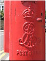
Edward VII postbox, Selhurst Road / Prince Road, SE25 - royal cipher
See Image
Image: © Mike Quinn
Taken: 4 Jul 2008
0.06 miles
3
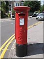
Edward VII postbox, Selhurst Road / Prince Road, SE25
Image: © Mike Quinn
Taken: 4 Jul 2008
0.07 miles
4
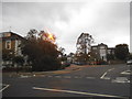
Prince Road at the junction of Selhurst Road
Image: © David Howard
Taken: 18 Oct 2015
0.07 miles
5
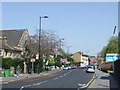
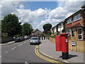
Selhurst Road, near South Norwood
A view of Selhurst Road, taken from opposite Selhurst railway station.
Image: © Malc McDonald
Taken: 10 Apr 2011
0.09 miles
6
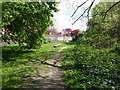
Path, Heavers Meadow
Along the north side of the wet area, this is the more pleasant and natural side.
Image: © Robin Webster
Taken: 19 Apr 2019
0.11 miles
7

Aerosol...the bricks, Heavers Meadow
On the north side of the wet area.
Image: © Robin Webster
Taken: 19 Apr 2019
0.11 miles
8

Real Life
Seen at the boundary of Heavers Meadow.
Heavers Meadow is a meadow located in South Norwood and Selhurst in the London Borough of Croydon. The meadow covers an area of 8.75 acres (3.34 hectares).
In 1935, the area of Heavers Meadow, and the adjacent allotments, was passed to Croydon Corporation by the Ecclesiastical Commissioners, to be used as an open space or recreation ground and allotments.
Image: © Peter Trimming
Taken: 1 Dec 2020
0.11 miles
9
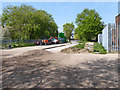
Temporarily fenced off part of Heavers Meadow
It looks like some sort of resurfacing work, but why it is needed is a bit of a mystery.
Image: © Robin Webster
Taken: 19 Apr 2019
0.11 miles
10
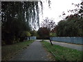
Path beside Norbury Brook
A path leads beside this stream (within a concrete ditch and metal fencing, on the right) and then heads beside the railway to Tennison Road, near Heavers Farm School.
Image: © David Anstiss
Taken: 30 Oct 2011
0.11 miles