IMAGES TAKEN NEAR TO
High Street, LONDON, SE25 6EB
Introduction
This page details the photographs taken nearby to High Street, SE25 6EB by members of the Geograph project.
The Geograph project started in 2005 with the aim of publishing, organising and preserving representative images for every square kilometre of Great Britain, Ireland and the Isle of Man.

There are currently over 7.5m images from over14,400 individuals and you can help contribute to the project by visiting https://www.geograph.org.uk
Image Map
Images are licensed for reuse under creativecommons.org/licenses/by-sa/2.0
Notes
- Clicking on the map will re-center to the selected point.
- The higher the marker number, the further away the image location is from the centre of the postcode.
Image Listing (234 Images Found)
Images are licensed for reuse under creativecommons.org/licenses/by-sa/2.0
Image
Details
Distance
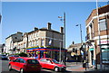
2
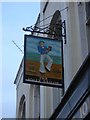
South Norwood: The Jolly Sailor
Before the railway line was built on approximately the same course, the Croydon Canal ran along the end of the Jolly Sailor's garden, and boats could be hired there for pleasure excursions. When the railway arrived, for some time the nearby station (now Norwood Junction) was called Jolly Sailor.
Image: © Christopher Hilton
Taken: 7 Jan 2010
0.02 miles
4
South Norwood: The Jolly Sailor
Before the railway line was built on approximately the same course, the Croydon Canal ran along the end of the Jolly Sailor's garden, and boats could be hired there for pleasure excursions. When the railway arrived, for some time the nearby station (now Norwood Junction) was called Jolly Sailor.
Image: © Christopher Hilton
Taken: 7 Jan 2010
0.04 miles
6
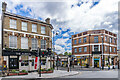
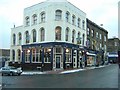
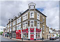
The Albion
19th Century pub at the junction of High Street and Portland Road, licensed in 1870. The building on the right was built c.1926 and originally occupied by Lloyds Bank.
Image: © Ian Capper
Taken: 6 Jul 2024
0.04 miles
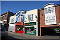
9
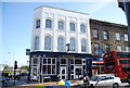
7 - 10 High Street
Building on the corner of High Street and St Dunstan's Road. Nos 7 - 8, towards the left, houses the Shelverdine Goathouse pub, formerly a Wetherspoon's pub named The William Stanley.
Image: © Ian Capper
Taken: 6 Jul 2024
0.05 miles
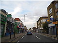
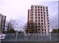
10
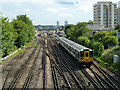
View towards Norwood Junction station
Unit 455 824 accelerates away from the station on an up train. In the station is a class 442 unit showing headlights. As these are not regularly used on the London Bridge route, it is probably about to reverse either into or out of Selhurst Depot beyond the distant bridge.
Image: © Robin Webster
Taken: 11 Jun 2011
0.05 miles