IMAGES TAKEN NEAR TO
Suffolk Road, LONDON, SE25 6BF
Introduction
This page details the photographs taken nearby to Suffolk Road, SE25 6BF by members of the Geograph project.
The Geograph project started in 2005 with the aim of publishing, organising and preserving representative images for every square kilometre of Great Britain, Ireland and the Isle of Man.

There are currently over 7.5m images from over14,400 individuals and you can help contribute to the project by visiting https://www.geograph.org.uk
Image Map
Images are licensed for reuse under creativecommons.org/licenses/by-sa/2.0
Notes
- Clicking on the map will re-center to the selected point.
- The higher the marker number, the further away the image location is from the centre of the postcode.
Image Listing (222 Images Found)
Images are licensed for reuse under creativecommons.org/licenses/by-sa/2.0
Image
Details
Distance
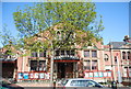
2
Stanley Hall
A grade II listed building built along with Stanley Technical High School in the 1900s.
Image: © Robin Webster
Taken: 11 Jun 2011
0.02 miles
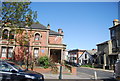
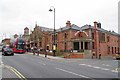
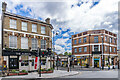
3
Stanley Hall
Arts venue on South Norwood Hill, part of a complex built 1902-9 which included Stanley Technical High School, now part of Harris Academy South Norwood. It was designed and funded by local inventor, manufacturer and philanthropist William Stanley. The main hall, seen here, was the first part to be completed, in 1903. The whole complex is grade II listed - see https://historicengland.org.uk/listing/the-list/list-entry/1252932?section=official-list-entry.
Image: © Ian Capper
Taken: 6 Jul 2024
0.03 miles
4
Older building, Harris Academy
For the full story of this building, see Image
Image: © Robin Webster
Taken: 11 Jun 2011
0.03 miles
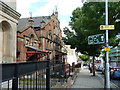
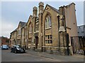
6
Stanley Halls
The Halls were built by W.F.R Stanley see Image for more information.
For a view from the other direction from 2005
see Image
The former Image is also part of the same complex.
There is also a Cafe with a Image hidden at the back.
Image: © Glyn Baker
Taken: 27 Mar 2019
0.03 miles
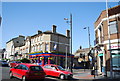
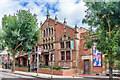
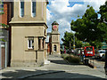
9
The Albion
19th Century pub at the junction of High Street and Portland Road, licensed in 1870. The building on the right was built c.1926 and originally occupied by Lloyds Bank.
Image: © Ian Capper
Taken: 6 Jul 2024
0.03 miles