IMAGES TAKEN NEAR TO
Enmore Road, LONDON, SE25 5NT
Introduction
This page details the photographs taken nearby to Enmore Road, SE25 5NT by members of the Geograph project.
The Geograph project started in 2005 with the aim of publishing, organising and preserving representative images for every square kilometre of Great Britain, Ireland and the Isle of Man.

There are currently over 7.5m images from over14,400 individuals and you can help contribute to the project by visiting https://www.geograph.org.uk
Image Map
Images are licensed for reuse under creativecommons.org/licenses/by-sa/2.0
Notes
- Clicking on the map will re-center to the selected point.
- The higher the marker number, the further away the image location is from the centre of the postcode.
Image Listing (36 Images Found)
Images are licensed for reuse under creativecommons.org/licenses/by-sa/2.0
Image
Details
Distance
1
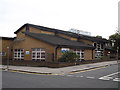
Woodside Health Centre, Woodside
On the junction of Enmore Road (in front) and Denmark Road (on the right).
Image: © David Anstiss
Taken: 16 Oct 2011
0.02 miles
2
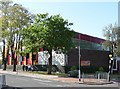
Swimming baths, Portland Road
A colourful building of brick and glass, designed by the Borough Architect, Hugh Lea, in 1967-68.
Image: © Stephen Richards
Taken: Unknown
0.04 miles
3
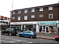
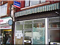
Shops on Portland Road
A small Tesco's Express supermarket and Lloyds Pharmacy.
Image: © David Anstiss
Taken: 16 Oct 2011
0.05 miles
4
Portland Road, South Norwood: coal merchant sign
Portland Road is not an affluent area by a long way, and that seems to have meant that a lot of the shops in it were never subjected to expensive, trendy makeovers. This "Coal Board Approved" sign lasted well into the 21st century, although now (2010) it has gone, sadly.
Image: © Christopher Hilton
Taken: 3 Jun 2005
0.06 miles
5
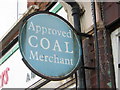
Portland Road, South Norwood: coal merchant sign
Portland Road is not an affluent area by a long way, and that seems to have meant that a lot of the shops in it were never subjected to expensive, trendy makeovers. This "Coal Board Approved" sign lasted well into the 21st century, although now (2010) it has gone, sadly.
Image: © Christopher Hilton
Taken: 3 Jun 2005
0.06 miles
6
Portland Road, South Norwood: shops, south end
Portland Road is not an affluent area by a long way, and that seems to have meant that a lot of the shops in it were never subjected to expensive, trendy makeovers. This "Coal Board Approved" sign lasted well into the 21st century, although now (2010) it has gone, sadly.
Image: © Christopher Hilton
Taken: 3 Jun 2005
0.06 miles
7
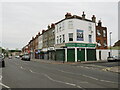
Portland Road, South Norwood
Portland Road in South Norwood, in the outer suburbs of south London.
Image: © Malc McDonald
Taken: 18 Jun 2022
0.06 miles
8
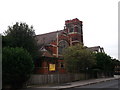
South Woodside United Reformed Church, Woodside
Large church on the junction of Enmore road (in front) and Cobden Road (behind the church).
Image: © David Anstiss
Taken: 16 Oct 2011
0.06 miles
9
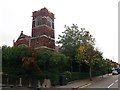
South Woodside United Reformed Church, Woodside (2)
Large church on the junction of Enmore road (on the left) and Cobden Road (on the right).
Image: © David Anstiss
Taken: 16 Oct 2011
0.07 miles
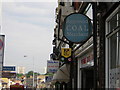
10
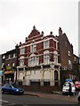
Ocean's Apart, South Norwood
Closed (in September 2000) former public house on 152 Portland Road.
It was once the 'Prince of Denmark'.
Image: © David Anstiss
Taken: 16 Oct 2011
0.07 miles