IMAGES TAKEN NEAR TO
Gresham Road, LONDON, SE25 5JT
Introduction
This page details the photographs taken nearby to Gresham Road, SE25 5JT by members of the Geograph project.
The Geograph project started in 2005 with the aim of publishing, organising and preserving representative images for every square kilometre of Great Britain, Ireland and the Isle of Man.

There are currently over 7.5m images from over14,400 individuals and you can help contribute to the project by visiting https://www.geograph.org.uk
Image Map
Images are licensed for reuse under creativecommons.org/licenses/by-sa/2.0
Notes
- Clicking on the map will re-center to the selected point.
- The higher the marker number, the further away the image location is from the centre of the postcode.
Image Listing (187 Images Found)
Images are licensed for reuse under creativecommons.org/licenses/by-sa/2.0
Image
Details
Distance
3
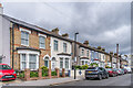
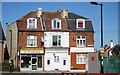
Carmichael Road
Late 19th Century housing in Carmichael Road. Most of the pairs have name plaques - nearest is Montrose Villas, then the next pair's plaque is ornamental, and then beyond is Montrose Villa with a date of 1878.
Image: © Ian Capper
Taken: 6 Jul 2024
0.04 miles
6
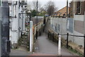
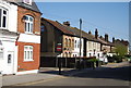
Footpath from Norwood Junction
This path gives access to the rear of properties along Carmichael Road
Image: © Dr Neil Clifton
Taken: 23 Mar 2016
0.06 miles
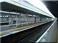
8
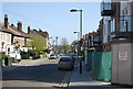
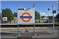
Clifford Road, looking southeast from Norwood Junction station
Image: © Dr Neil Clifton
Taken: 23 Mar 2016
0.06 miles
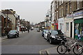
10
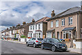
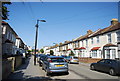
Carmichael Road
Late 19th Century housing in Carmichael Road.
Image: © Ian Capper
Taken: 6 Jul 2024
0.07 miles