IMAGES TAKEN NEAR TO
Hermitage Lane, LONDON, SE25 5HH
Introduction
This page details the photographs taken nearby to Hermitage Lane, SE25 5HH by members of the Geograph project.
The Geograph project started in 2005 with the aim of publishing, organising and preserving representative images for every square kilometre of Great Britain, Ireland and the Isle of Man.

There are currently over 7.5m images from over14,400 individuals and you can help contribute to the project by visiting https://www.geograph.org.uk
Image Map
Images are licensed for reuse under creativecommons.org/licenses/by-sa/2.0
Notes
- Clicking on the map will re-center to the selected point.
- The higher the marker number, the further away the image location is from the centre of the postcode.
Image Listing (99 Images Found)
Images are licensed for reuse under creativecommons.org/licenses/by-sa/2.0
Image
Details
Distance
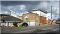
6
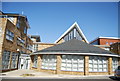
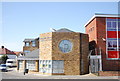
Woodside Green Christian Centre
The building with the circular window is part of the quite large site. A view out of the closed off end of Blackhorse Lane, closed whilst bridge repair work is in progress.
Image: © Robin Webster
Taken: 19 Apr 2019
0.04 miles
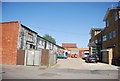
9
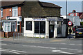
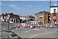
LJ's Snack Bar
On the corner of Morland Road (B243) and Hermitage Lane.
Image: © Robin Webster
Taken: 19 Apr 2019
0.04 miles
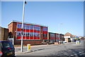
10
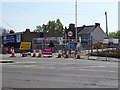
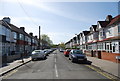
Closed Blackhorse Lane
Closed whilst bridge repair work is in progress.
Image: © Robin Webster
Taken: 19 Apr 2019
0.05 miles