IMAGES TAKEN NEAR TO
Lincoln Close, LONDON, SE25 5ET
Introduction
This page details the photographs taken nearby to Lincoln Close, SE25 5ET by members of the Geograph project.
The Geograph project started in 2005 with the aim of publishing, organising and preserving representative images for every square kilometre of Great Britain, Ireland and the Isle of Man.

There are currently over 7.5m images from over14,400 individuals and you can help contribute to the project by visiting https://www.geograph.org.uk
Image Map
Images are licensed for reuse under creativecommons.org/licenses/by-sa/2.0
Notes
- Clicking on the map will re-center to the selected point.
- The higher the marker number, the further away the image location is from the centre of the postcode.
Image Listing (113 Images Found)
Images are licensed for reuse under creativecommons.org/licenses/by-sa/2.0
Image
Details
Distance
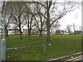
1
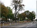
Woodside Green
This sliver of Open-access green is beside Woodside Green (road on the right) and another shorter section of Woodside Green (road on the left).
Image: © David Anstiss
Taken: 16 Oct 2011
0.05 miles
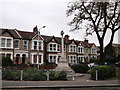
2
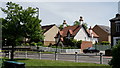
Woodside
Housing at the junction of Woodside Green and Stroud Road.
Image: © Peter Trimming
Taken: 17 May 2020
0.06 miles

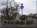
4
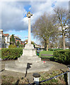
Memorial, Woodside Green
War memorial at the southern end of the green.
Image: © Des Blenkinsopp
Taken: 11 Feb 2020
0.07 miles
5
Woodside
The war memorial in the foreground, with the green behind.
Image: © Peter Trimming
Taken: 17 May 2020
0.07 miles
7
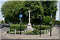
Woodside War Memorial
On Woodside Green at the end of Image
Image: © David Anstiss
Taken: 16 Oct 2011
0.08 miles
9
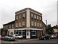
No.34 Elmer's Road, Woodside
Former shop (or pub?), now converted into housing on the corner of Elmer's Road (on the right).
Image: © David Anstiss
Taken: 16 Oct 2011
0.09 miles
10
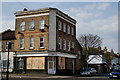
South Norwood
34 Stroud Road, the Railway Tavern Beer Retailer Shop (Croydon 1911 pub history census summary).
Image: © Peter Trimming
Taken: 11 Apr 2020
0.09 miles