IMAGES TAKEN NEAR TO
Saxon Road, LONDON, SE25 5EQ
Introduction
This page details the photographs taken nearby to Saxon Road, SE25 5EQ by members of the Geograph project.
The Geograph project started in 2005 with the aim of publishing, organising and preserving representative images for every square kilometre of Great Britain, Ireland and the Isle of Man.

There are currently over 7.5m images from over14,400 individuals and you can help contribute to the project by visiting https://www.geograph.org.uk
Image Map
Images are licensed for reuse under creativecommons.org/licenses/by-sa/2.0
Notes
- Clicking on the map will re-center to the selected point.
- The higher the marker number, the further away the image location is from the centre of the postcode.
Image Listing (108 Images Found)
Images are licensed for reuse under creativecommons.org/licenses/by-sa/2.0
Image
Details
Distance
2
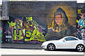
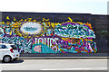
Aerosol...the bricks - Newhaven Road, Selhurst
On the side of the railway embankment.
Image: © Robin Webster
Taken: 19 Apr 2019
0.07 miles
3
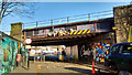
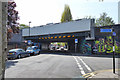
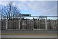
Railway Bridge, Dagnall Park, Selhurst
The main London to Brighton line crosses this railway bridge which is adjacent to Selhurst Station.
The three small yellow security cameras have not deterred the graffiti artists or the placing of soft toys on the bridge.
See https://www.geograph.org.uk/photo/1466263 for a view of the other side of the bridge.
Image: © Robin Drayton
Taken: 20 Jan 2019
0.07 miles
4
Aerosol...the bricks - Newhaven Road, Selhurst
On the side of the railway embankment.
Image: © Robin Webster
Taken: 19 Apr 2019
0.07 miles
5
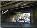
Railway bridges VTB1 55 and 55A
Side by side bridges on the direct Victoria - East Croydon route. The road under, Dagnall Park, is closed to vehicles except cycles.
Image: © Robin Webster
Taken: 19 Apr 2019
0.07 miles
6
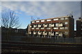
Railway Bridge at Dagnall Park, Selhurst
The main line from London to Brighton runs over this bridge. Selhurst station is just to the left, reached via a short footpath.
Image: © Peter Trimming
Taken: 28 Aug 2009
0.08 miles
7
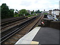
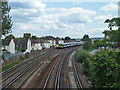
Looking up the line from Selhurst station
The Balham Hill & East Croydon line was constructed by the London Brighton & South Coast Railway as a short-cut on the main Brighton line from London Victoria, avoiding Crystal Palace and Norwood Junction. It was opened on 1st December 1862, and Selhurst station opened three years later in 1865. The lines were quadrupled in 1903, and electrified in 1912. In this photograph the two stopping lines are on this side and the fast lines are on the far left. Newhaven Road is to the right of the lines.
Image: © Marathon
Taken: 6 Jun 2012
0.08 miles
9
Railway towards Selhurst station
And onwards to East Croydon and points south.
Image: © Robin Webster
Taken: 29 Jun 2011
0.09 miles