IMAGES TAKEN NEAR TO
Fouracre Path, LONDON, SE25 5DZ
Introduction
This page details the photographs taken nearby to Fouracre Path, SE25 5DZ by members of the Geograph project.
The Geograph project started in 2005 with the aim of publishing, organising and preserving representative images for every square kilometre of Great Britain, Ireland and the Isle of Man.

There are currently over 7.5m images from over14,400 individuals and you can help contribute to the project by visiting https://www.geograph.org.uk
Image Map
Images are licensed for reuse under creativecommons.org/licenses/by-sa/2.0
Notes
- Clicking on the map will re-center to the selected point.
- The higher the marker number, the further away the image location is from the centre of the postcode.
Image Listing (117 Images Found)
Images are licensed for reuse under creativecommons.org/licenses/by-sa/2.0
Image
Details
Distance
2
Sehurst Road A213
Viewed from East Crodon to Victoria Station railway line.
Image: © Russel Wills
Taken: 17 May 2014
0.05 miles
3
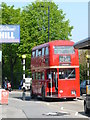
London Transport RT Bus
The RT series pre-dates the famous Routemaster (RM) bus, and this bus must be at least 50 years old. I presume that it was on some kind of private charter; it had been parked at the bus stop in Selhurst Road, however, as I approached, the bus pulled away.
Image: © Peter Trimming
Taken: 24 Apr 2009
0.05 miles
4
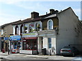
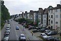
Pepperton's Restaurant
This late Victorian terrace has Pepperton's Restaurant and Art Gallery in the centre.
The restaurant is run by Celestine & Bula Agbo. Celestine ran in the 1995 London Marathon ...... backwards! He has completed the event at least 13 times.
Image: © Peter Trimming
Taken: 24 Apr 2009
0.06 miles
5
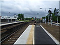
Looking down the line from Selhurst station
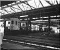
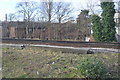
The Balham Hill & East Croydon line was constructed by the London Brighton & South Coast Railway as a short-cut on the main Brighton line from London Victoria, avoiding Crystal Palace and Norwood Junction. It was opened on 1st December 1862, and Selhurst station opened three years later in 1865. The lines were quadrupled in 1903, and electrified in 1912. In this photograph the two stopping lines are on the left and the fast lines are on the far right. The line splits ahead with the left hand curve leading to Selhurst Depot or Norwood Junction and straight on goes to East or West Croydon.
Image: © Marathon
Taken: 6 Jun 2012
0.06 miles
6
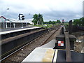
Looking down the line from the platform at Selhurst station
The Balham Hill & East Croydon line was constructed by the London Brighton & South Coast Railway as a short-cut on the main Brighton line from London Victoria, avoiding Crystal Palace and Norwood Junction. It was opened on 1st December 1862, and Selhurst station opened three years later in 1865. The lines were quadrupled in 1903, and electrified in 1912. In this photograph the two stopping lines are on the left and the fast lines are on the far right. The line splits ahead with the left hand curve leading to Selhurst Depot or Norwood Junction and straight on goes to East or West Croydon. The bridge just beyond the platform is over Selhurst Road.
Image: © Marathon
Taken: 6 Jun 2012
0.07 miles
8
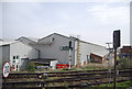
The Selhurst Arms, Selhurst Road, Selhurst
Located on the junction with Selhurst New Road. Selhurst is a common name in these parts, relating to the times when much of the area was densely wooded (the Great North Wood), as far as Norwood. I note that the pub is still "to let". In 35 years, I can count my visits, to this establishment, on the fingers of one hand.
Image: © Peter Trimming
Taken: 23 Sep 2010
0.07 miles