IMAGES TAKEN NEAR TO
Tennison Road, LONDON, SE25 5DL
Introduction
This page details the photographs taken nearby to Tennison Road, SE25 5DL by members of the Geograph project.
The Geograph project started in 2005 with the aim of publishing, organising and preserving representative images for every square kilometre of Great Britain, Ireland and the Isle of Man.

There are currently over 7.5m images from over14,400 individuals and you can help contribute to the project by visiting https://www.geograph.org.uk
Image Map
Images are licensed for reuse under creativecommons.org/licenses/by-sa/2.0
Notes
- Clicking on the map will re-center to the selected point.
- The higher the marker number, the further away the image location is from the centre of the postcode.
Image Listing (80 Images Found)
Images are licensed for reuse under creativecommons.org/licenses/by-sa/2.0
Image
Details
Distance
6
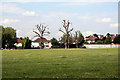
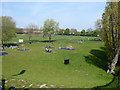
Croydon: Polled trees in South Norwood Recreation Ground
Image: © Dr Neil Clifton
Taken: 14 Jun 2010
0.14 miles
7
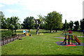
Croydon: South Norwood Recreation Ground
This small well-kept park with children's play area can be entered from Tennison Road just west of the bridge.
Image: © Dr Neil Clifton
Taken: 14 Jun 2010
0.15 miles
8
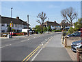
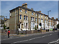
Park Road at the junction of Selhurst Road
Image: © David Howard
Taken: 7 Oct 2012
0.16 miles
10
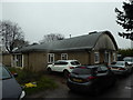
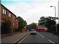
Holy Innocents, South Norwood: church hall
Image: © Basher Eyre
Taken: 20 Jan 2018
0.17 miles