IMAGES TAKEN NEAR TO
Belgrave Road, LONDON, SE25 5AL
Introduction
This page details the photographs taken nearby to Belgrave Road, SE25 5AL by members of the Geograph project.
The Geograph project started in 2005 with the aim of publishing, organising and preserving representative images for every square kilometre of Great Britain, Ireland and the Isle of Man.

There are currently over 7.5m images from over14,400 individuals and you can help contribute to the project by visiting https://www.geograph.org.uk
Image Map
Images are licensed for reuse under creativecommons.org/licenses/by-sa/2.0
Notes
- Clicking on the map will re-center to the selected point.
- The higher the marker number, the further away the image location is from the centre of the postcode.
Image Listing (233 Images Found)
Images are licensed for reuse under creativecommons.org/licenses/by-sa/2.0
Image
Details
Distance
3
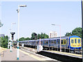
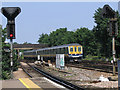
Thameslink new livery (post-2005)
The Thameslink train franchise changed its livery in 2005. Unit 319427 is seen here passing through Norwood Junction on an up service on 28 June in the new livery. Compare Image
Image: © Stephen Craven
Taken: 28 Jun 2005
0.04 miles
4

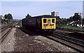
Arriving At Norwood Junction
4-EPB set number 5015 leads an eight coach formation into Norwood Junction station on route to Caterham with Crystal Palace mast as a backdrop. This unit was built in 1951. Many of the class were withdrawn in the mid-1980's though others were refurbished and returned to service. The last of the type were finally withdrawn in 1995.
Image: © Martin Addison
Taken: Unknown
0.04 miles
5
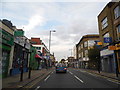
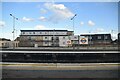
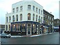
7 - 10 High Street
Building on the corner of High Street and St Dunstan's Road. Nos 7 - 8, towards the left, houses the Shelverdine Goathouse pub, formerly a Wetherspoon's pub named The William Stanley.
Image: © Ian Capper
Taken: 6 Jul 2024
0.04 miles
6
Thameslink old livery (pre-2005)
The Thameslink rail franchise changed its livery in 2005. Here the 'old' livery is still carried by unit 319450 on a down service through Norwood Junction on 28 June. See also Image
Image: © Stephen Craven
Taken: 28 Jun 2005
0.05 miles
7
Engineering Stores
Stores unit number 023 runs through Norwood Junction, almost certainly on its way into Selhurst depot where it could usually be found during the 1970's. The coaches of the unit are from 2-HAL units that were built in 1938/39 for the extension of electrification to Gillingham and Maidstone. Each vehicle is a Motor Brake Second taken from 2-HAL's numbers 2624 and 2642. They were converted for stores use in 1970 and remained in use until 1987 when they were finally withdrawn and scrapped.
Image: © Martin Addison
Taken: Unknown
0.05 miles
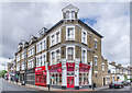
9
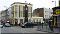
South Norwood
Junction of High Street and Station Road. Clock tower and the Alliance PH are visible in the centre of picture.
Image: © Peter Trimming
Taken: 28 Feb 2009
0.05 miles
10
South Norwood: The Jolly Sailor
Before the railway line was built on approximately the same course, the Croydon Canal ran along the end of the Jolly Sailor's garden, and boats could be hired there for pleasure excursions. When the railway arrived, for some time the nearby station (now Norwood Junction) was called Jolly Sailor.
Image: © Christopher Hilton
Taken: 7 Jan 2010
0.05 miles