IMAGES TAKEN NEAR TO
Watcombe Road, LONDON, SE25 4UZ
Introduction
This page details the photographs taken nearby to Watcombe Road, SE25 4UZ by members of the Geograph project.
The Geograph project started in 2005 with the aim of publishing, organising and preserving representative images for every square kilometre of Great Britain, Ireland and the Isle of Man.

There are currently over 7.5m images from over14,400 individuals and you can help contribute to the project by visiting https://www.geograph.org.uk
Image Map
Images are licensed for reuse under creativecommons.org/licenses/by-sa/2.0
Notes
- Clicking on the map will re-center to the selected point.
- The higher the marker number, the further away the image location is from the centre of the postcode.
Image Listing (57 Images Found)
Images are licensed for reuse under creativecommons.org/licenses/by-sa/2.0
Image
Details
Distance
1
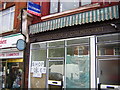
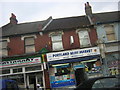
Portland Road, South Norwood: shops, south end
Portland Road is not an affluent area by a long way, and that seems to have meant that a lot of the shops in it were never subjected to expensive, trendy makeovers. This "Coal Board Approved" sign lasted well into the 21st century, although now (2010) it has gone, sadly.
Image: © Christopher Hilton
Taken: 3 Jun 2005
0.08 miles
2
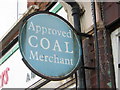
Portland Road, South Norwood: coal merchant sign
Portland Road is not an affluent area by a long way, and that seems to have meant that a lot of the shops in it were never subjected to expensive, trendy makeovers. This "Coal Board Approved" sign lasted well into the 21st century, although now (2010) it has gone, sadly.
Image: © Christopher Hilton
Taken: 3 Jun 2005
0.08 miles
3
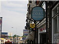
Portland Road, South Norwood: coal merchant sign
Portland Road is not an affluent area by a long way, and that seems to have meant that a lot of the shops in it were never subjected to expensive, trendy makeovers. This "Coal Board Approved" sign lasted well into the 21st century, although now (2010) it has gone, sadly.
Image: © Christopher Hilton
Taken: 3 Jun 2005
0.08 miles
5
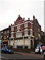
Ocean's Apart, South Norwood
Closed (in September 2000) former public house on 152 Portland Road.
It was once the 'Prince of Denmark'.
Image: © David Anstiss
Taken: 16 Oct 2011
0.10 miles
6
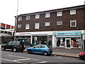
Shops on Portland Road
A small Tesco's Express supermarket and Lloyds Pharmacy.
Image: © David Anstiss
Taken: 16 Oct 2011
0.11 miles
7
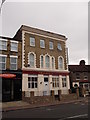
The Gladstone, South Norwood
This house on 167 Portland Road, used to be the Gladstone Public House.
See http://www.beerintheevening.com/pubs/s/15/15328/Gladstone/South_Norwood for an image when it was a pub.
Image: © David Anstiss
Taken: 16 Oct 2011
0.11 miles
8
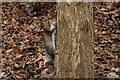
Grey Squirrel
Seen at the edge of South Norwood Country Park.
Image: © Peter Trimming
Taken: 1 Jan 2021
0.13 miles
9
Portland Road, South Norwood: The Rastarant
The Rastarant, sadly, now (end 2010) seems to have closed, so this snatched shot out of a moving car is probably the best I'll ever get of it: I meant to go back and shoot it properly, but never made the time, alas. Still, this records it, even if in a rather drunken fashion.
Image: © Christopher Hilton
Taken: 13 Jul 2009
0.13 miles
10
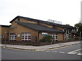
Woodside Health Centre, Woodside
On the junction of Enmore Road (in front) and Denmark Road (on the right).
Image: © David Anstiss
Taken: 16 Oct 2011
0.15 miles