IMAGES TAKEN NEAR TO
Estcourt Road, LONDON, SE25 4SB
Introduction
This page details the photographs taken nearby to Estcourt Road, SE25 4SB by members of the Geograph project.
The Geograph project started in 2005 with the aim of publishing, organising and preserving representative images for every square kilometre of Great Britain, Ireland and the Isle of Man.

There are currently over 7.5m images from over14,400 individuals and you can help contribute to the project by visiting https://www.geograph.org.uk
Image Map
Images are licensed for reuse under creativecommons.org/licenses/by-sa/2.0
Notes
- Clicking on the map will re-center to the selected point.
- The higher the marker number, the further away the image location is from the centre of the postcode.
Image Listing (53 Images Found)
Images are licensed for reuse under creativecommons.org/licenses/by-sa/2.0
Image
Details
Distance
1
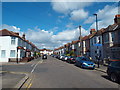
Estcourt Road, South Norwood
Estcourt Road is on the route of National Cycle Network route 21. The blue sign fixed to the lamp post indicates that the cycle route turns left here.
Image: © Malc McDonald
Taken: 21 Aug 2016
0.10 miles
4
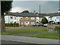
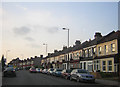
Small close off Longhurst Road
A curious angular terrace of houses with the end houses facing each other across the small roundabout. The arrangement is symmetrical about the angle behind the tree. There must be some very oddly shaped rooms.
Image: © Robin Webster
Taken: 11 Jun 2011
0.13 miles
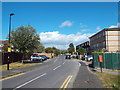
9
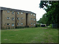
Flats, Shoreham Close
Shoreham Close is the other side of the block.
Image: © Robin Webster
Taken: 11 Jun 2011
0.15 miles
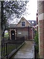
10
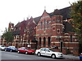
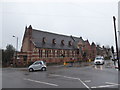
Church of St Luke, Woodside (2)
Large Grade II listed church on the junction of Portland Road (heading behind the church) and Shirley Road (in front).
See http://www.britishlistedbuildings.co.uk/en-201272-church-of-st-luke-croydon/photos for more details about the church.
Image: © David Anstiss
Taken: 16 Oct 2011
0.15 miles