IMAGES TAKEN NEAR TO
Westgate Road, LONDON, SE25 4NA
Introduction
This page details the photographs taken nearby to Westgate Road, SE25 4NA by members of the Geograph project.
The Geograph project started in 2005 with the aim of publishing, organising and preserving representative images for every square kilometre of Great Britain, Ireland and the Isle of Man.

There are currently over 7.5m images from over14,400 individuals and you can help contribute to the project by visiting https://www.geograph.org.uk
Image Map (Loading...)


Getting Data...Please wait
Leaflet Map data © OpenStreetMap
Images are licensed for reuse under creativecommons.org/licenses/by-sa/2.0
Notes
- Clicking on the map will re-center to the selected point.
- The higher the marker number, the further away the image location is from the centre of the postcode.
Image Listing (68 Images Found)
Images are licensed for reuse under creativecommons.org/licenses/by-sa/2.0
Image
Details
Distance
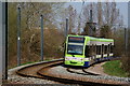
1
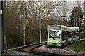
Tramlink
Seen passing through the edge of South Norwood Country Park.
Image: © Peter Trimming
Taken: 24 Dec 2020
0.07 miles
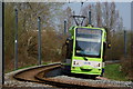
2
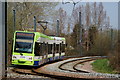
Tram in South Norwood Country Park
Speeding round a banked curve, heading in the direction of Beckenham Junction.
Image: © Peter Trimming
Taken: 22 Mar 2012
0.07 miles
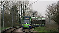
3
Tramlink
Tram passing through South Norwood Country Park.
Image: © Peter Trimming
Taken: 1 Jan 2021
0.07 miles
4
Tramlink
Tram passing through South Norwood Country Park.
Image: © Peter Trimming
Taken: 1 Jan 2021
0.07 miles
5
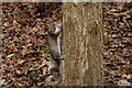
Grey Squirrel
Seen at the edge of South Norwood Country Park.
Image: © Peter Trimming
Taken: 1 Jan 2021
0.08 miles
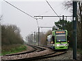
6
Tram in South Norwood Country Park
Seen speeding round the banked curve. This service, from Beckenham Junction, is for Elmers End via East and West Croydon.
Image: © Peter Trimming
Taken: 22 Mar 2012
0.08 miles
7
Tram in South Norwood Country Park
Seen speeding round the banked curve. This service, from Beckenham Junction, is for Elmers End via East and West Croydon.
Image: © Peter Trimming
Taken: 22 Mar 2012
0.08 miles
8
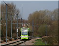
Tram in South Norwood Country Park
The branch of Tramlink, from Beckenham Junction, to Arena, passes through South Norwood Country Park. Here, the tram speeds towards Arena and Croydon.
Image: © Peter Trimming
Taken: 22 Mar 2012
0.09 miles
9
View of the sports centre from the Earth Mound #2
Looking north-northwest.
Image: © Robert Lamb
Taken: 14 Jul 2011
0.12 miles
10
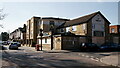
South Norwood
The former Albert Tavern, closed and likely to be re-developed as housing.
Image: © Peter Trimming
Taken: 27 Feb 2021
0.13 miles