IMAGES TAKEN NEAR TO
Cresswell Road, LONDON, SE25 4LS
Introduction
This page details the photographs taken nearby to Cresswell Road, SE25 4LS by members of the Geograph project.
The Geograph project started in 2005 with the aim of publishing, organising and preserving representative images for every square kilometre of Great Britain, Ireland and the Isle of Man.

There are currently over 7.5m images from over14,400 individuals and you can help contribute to the project by visiting https://www.geograph.org.uk
Image Map
Images are licensed for reuse under creativecommons.org/licenses/by-sa/2.0
Notes
- Clicking on the map will re-center to the selected point.
- The higher the marker number, the further away the image location is from the centre of the postcode.
Image Listing (88 Images Found)
Images are licensed for reuse under creativecommons.org/licenses/by-sa/2.0
Image
Details
Distance
1
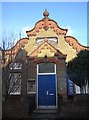
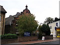
Portland Road: London City Mission Hall
Image: © Christopher Hilton
Taken: 30 Jan 2010
0.05 miles
2
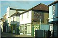
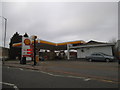
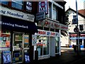
Portland Road, South Norwood: shops, north side
The premises with "United Dairies" on the side (and the gates on either side to allow milk floats entry to and exit from the yard behind) are now a Christian fellowship centre. Beyond is the Duke of Clarence pub.
Image: © Christopher Hilton
Taken: 30 Jan 2010
0.07 miles
3
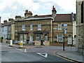
The Redeemed Christian Church of God, South Norwood
Originally the London City Mission Hall, built in 1889
Image: © David Howard
Taken: 6 Apr 2015
0.08 miles
4
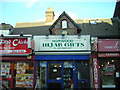
Portland Road, South Norwood: shops, north side
The shops along this stretch of the road have been built in what were the front gardens of small cottages. Hijab Gifts occupies a particularly interesting little building made of flint, although the shopfront largely masks the original structure.
Image: © Christopher Hilton
Taken: 30 Jan 2010
0.08 miles
5
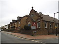
Portland Christian Centre, South Norwood
On the junction of Portland Road (in front) and Pembury Road (on the right).
Image: © David Anstiss
Taken: 16 Oct 2011
0.08 miles
7
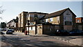
Houses on corner of Albert Road and Coventry Road, South Norwood
Image: © Robin Webster
Taken: 11 Jun 2011
0.10 miles
8
South Norwood
The former Albert Tavern, closed and likely to be re-developed as housing.
Image: © Peter Trimming
Taken: 27 Feb 2021
0.10 miles
9
The last of the old launderettes ... shortly before renovation
Image: © tristan forward
Taken: Unknown
0.10 miles
10
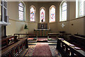
St Mark, Albert Road, South Norwood - Chancel
Image: © John Salmon
Taken: 11 Aug 2014
0.10 miles