IMAGES TAKEN NEAR TO
Lancaster Road, LONDON, SE25 4AR
Introduction
This page details the photographs taken nearby to Lancaster Road, SE25 4AR by members of the Geograph project.
The Geograph project started in 2005 with the aim of publishing, organising and preserving representative images for every square kilometre of Great Britain, Ireland and the Isle of Man.

There are currently over 7.5m images from over14,400 individuals and you can help contribute to the project by visiting https://www.geograph.org.uk
Image Map
Images are licensed for reuse under creativecommons.org/licenses/by-sa/2.0
Notes
- Clicking on the map will re-center to the selected point.
- The higher the marker number, the further away the image location is from the centre of the postcode.
Image Listing (92 Images Found)
Images are licensed for reuse under creativecommons.org/licenses/by-sa/2.0
Image
Details
Distance
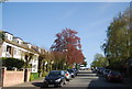
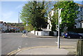
1
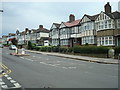
Lancaster Road, South Norwood
Showing the undulating nature of this road, which runs in the direction of South Norwood High Street.
Image: © Peter Trimming
Taken: 28 Aug 2009
0.03 miles
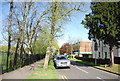
4
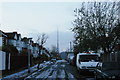
Court Road, winter
In the distance, the southern of the two Crystal Palace transmitter masts.
Image: © Christopher Hilton
Taken: 5 Dec 2010
0.07 miles
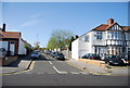
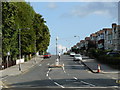
8
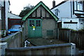
Electricity substation, Lancaster Road
Inter-war Tudorbethan semis predominate here, so the substation is designed to be in keeping with them.
Image: © Christopher Hilton
Taken: 5 Dec 2010
0.10 miles