IMAGES TAKEN NEAR TO
Herne Hill, LONDON, SE24 9QH
Introduction
This page details the photographs taken nearby to Herne Hill, SE24 9QH by members of the Geograph project.
The Geograph project started in 2005 with the aim of publishing, organising and preserving representative images for every square kilometre of Great Britain, Ireland and the Isle of Man.

There are currently over 7.5m images from over14,400 individuals and you can help contribute to the project by visiting https://www.geograph.org.uk
Image Map
Images are licensed for reuse under creativecommons.org/licenses/by-sa/2.0
Notes
- Clicking on the map will re-center to the selected point.
- The higher the marker number, the further away the image location is from the centre of the postcode.
Image Listing (168 Images Found)
Images are licensed for reuse under creativecommons.org/licenses/by-sa/2.0
Image
Details
Distance
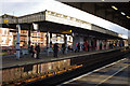
3
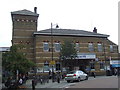
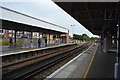
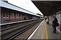
Herne Hill station
The railway station building at Herne Hill, South London.
Image: © Malc McDonald
Taken: 30 May 2011
0.03 miles

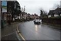
6
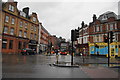
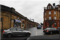
Herne Hill on a wet day
Both the road ahead and the suburb are called Herne Hill.
Image: © Bill Boaden
Taken: 31 Jan 2014
0.03 miles
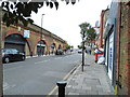
10
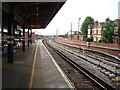
Railway arches at Herne Hill
Railway arches are always a good place to do business.
Image: © Bill Boaden
Taken: 31 Jan 2014
0.04 miles