IMAGES TAKEN NEAR TO
Hollingbourne Road, LONDON, SE24 9ND
Introduction
This page details the photographs taken nearby to Hollingbourne Road, SE24 9ND by members of the Geograph project.
The Geograph project started in 2005 with the aim of publishing, organising and preserving representative images for every square kilometre of Great Britain, Ireland and the Isle of Man.

There are currently over 7.5m images from over14,400 individuals and you can help contribute to the project by visiting https://www.geograph.org.uk
Image Map
Images are licensed for reuse under creativecommons.org/licenses/by-sa/2.0
Notes
- Clicking on the map will re-center to the selected point.
- The higher the marker number, the further away the image location is from the centre of the postcode.
Image Listing (99 Images Found)
Images are licensed for reuse under creativecommons.org/licenses/by-sa/2.0
Image
Details
Distance
7
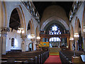
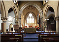
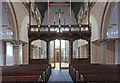
Interior of St Paul's church
The interior of St Paul's church Image taken on an earlier visit. As of 2012 the parish was seeking permission to reorder the church, including relocating the chancel screen (a WW1 war memorial) to form part of a new division between nave and narthex.
Image: © Stephen Craven
Taken: 19 Sep 2005
0.11 miles
9
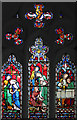
St Paul, Herne Hill - Stained glass window
Image: © John Salmon
Taken: 21 Jul 2014
0.11 miles
10
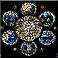
St Paul, Herne Hill - Stained glass window
Image: © John Salmon
Taken: 21 Jul 2014
0.11 miles