IMAGES TAKEN NEAR TO
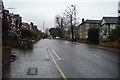
Carver Road, LONDON, SE24 9LT
Introduction
This page details the photographs taken nearby to Carver Road, SE24 9LT by members of the Geograph project.
The Geograph project started in 2005 with the aim of publishing, organising and preserving representative images for every square kilometre of Great Britain, Ireland and the Isle of Man.

There are currently over 7.5m images from over14,400 individuals and you can help contribute to the project by visiting https://www.geograph.org.uk
Image Map
Images are licensed for reuse under creativecommons.org/licenses/by-sa/2.0
Notes
- Clicking on the map will re-center to the selected point.
- The higher the marker number, the further away the image location is from the centre of the postcode.
Image Listing (160 Images Found)
Images are licensed for reuse under creativecommons.org/licenses/by-sa/2.0
Image
Details
Distance
2
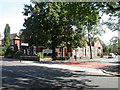
Herne Hill Baptist Church
At the junction of Half Moon Lane and Winterbrook Road, partially obscured by foliage. http://www.hernehillbaptistchurch.org/
Image: © Mike Faherty
Taken: 16 Aug 2009
0.06 miles
3
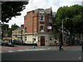
Herne Hill, disused bank
At the junction of Half Moon Lane & Stradella Road; the name "Lloyds Bank" can be made out on the fascia.
Image: © Mike Faherty
Taken: 22 Aug 2009
0.07 miles
6
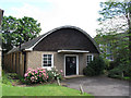
St Paul's hall, Herne Hill
A nondescript mid-20th century church hall in the grounds of the much more attractive, and listed, parish church Image
Image: © Stephen Craven
Taken: 6 Jul 2012
0.08 miles

8
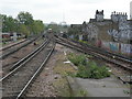
View South from Platform 2 at Herne Hill Station
An Orpington to Victoria train is on its way into the station. The right fork of this rail junction goes towards Sutton or Wimbledon and is used by First Capital Connect trains. The bridge ahead is the one you see at street level in http://www.geograph.org.uk/photo/407202 The mast at top dead centre of shot is the TV mast at Crystal Palace. Graffiti "artists" have been busy -- I'll bet they didn't do a Health and Safety Risk Assessment before painting started. Not least amongst the hazards would have been a 750 volt live rail just inches from where their feet were.
Image: © Danny P Robinson
Taken: 20 Apr 2007
0.08 miles
9
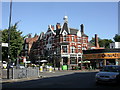
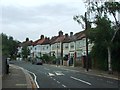
Herne Hill, The Half Moon
Busy Victorian pub at junction Norwood Road & Half Moon Lane. Internally, central bar, drinking areas on three sides, good glass- and woodwork, including painted glass murals in former snug. Cask ales available at my visit: Adnam's Bitter, Fuller's London Pride, Wadworth's 6X. For some customer reviews, see http://www.beerintheevening.com/pubs/s/59/5996/Half_Moon/Herne_HIll
Image: © Mike Faherty
Taken: 16 Aug 2009
0.08 miles
10
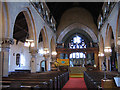
Interior of St Paul's church
The interior of St Paul's church Image taken on an earlier visit. As of 2012 the parish was seeking permission to reorder the church, including relocating the chancel screen (a WW1 war memorial) to form part of a new division between nave and narthex.
Image: © Stephen Craven
Taken: 19 Sep 2005
0.08 miles