IMAGES TAKEN NEAR TO
Holmdene Avenue, LONDON, SE24 9LE
Introduction
This page details the photographs taken nearby to Holmdene Avenue, SE24 9LE by members of the Geograph project.
The Geograph project started in 2005 with the aim of publishing, organising and preserving representative images for every square kilometre of Great Britain, Ireland and the Isle of Man.

There are currently over 7.5m images from over14,400 individuals and you can help contribute to the project by visiting https://www.geograph.org.uk
Image Map
Images are licensed for reuse under creativecommons.org/licenses/by-sa/2.0
Notes
- Clicking on the map will re-center to the selected point.
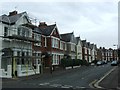
- The higher the marker number, the further away the image location is from the centre of the postcode.
Image Listing (89 Images Found)
Images are licensed for reuse under creativecommons.org/licenses/by-sa/2.0
Image
Details
Distance
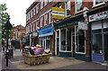
3
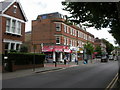
Herne Hill, shopping parade
Victorian-looking parade on Half Moon Lane, with convenience store,(vacant), fish and chips shop, accountants, delicatessen & off-licence.
Image: © Mike Faherty
Taken: 22 Aug 2009
0.06 miles
4
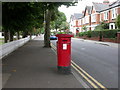
Herne Hill, cypherless postbox
On Half Moon Lane, a postbox without its royal cypher.
Image: © Mike Faherty
Taken: 22 Aug 2009
0.08 miles
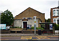
6
Half Moon Lane, Herne Hill
A parade of shops on the north side. The furniture shop appears to be due for a change.
Image: © Ian Taylor
Taken: 22 Sep 2013
0.08 miles
10
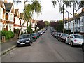
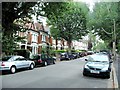
Herne Hill: Elfindale Road, SE24
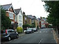
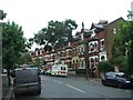
Elfindale is one of several residential roads that were built in Edwardian times in the triangle of land between Half Moon Lane and the road known as Herne Hill. On the 1899 Ordnance Survey map the area is virtually empty with only the two roads parallel to Elfindale, Holmdene Avenue and Hollingbourne Road, being shown and then with only a few houses. By 1916 the map shows the whole estate from Danecroft Road south-westwards as being developed.
Image: © Nigel Cox
Taken: 11 Sep 2009
0.12 miles