IMAGES TAKEN NEAR TO
Croxted Road, LONDON, SE24 9DA
Introduction
This page details the photographs taken nearby to Croxted Road, SE24 9DA by members of the Geograph project.
The Geograph project started in 2005 with the aim of publishing, organising and preserving representative images for every square kilometre of Great Britain, Ireland and the Isle of Man.

There are currently over 7.5m images from over14,400 individuals and you can help contribute to the project by visiting https://www.geograph.org.uk
Image Map
Images are licensed for reuse under creativecommons.org/licenses/by-sa/2.0
Notes
- Clicking on the map will re-center to the selected point.
- The higher the marker number, the further away the image location is from the centre of the postcode.
Image Listing (88 Images Found)
Images are licensed for reuse under creativecommons.org/licenses/by-sa/2.0
Image
Details
Distance
2
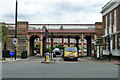
Railway bridge HHT 519
The Herne Hill to Tulse Hill line crosses Croxted Road on an ornate bridge. A quite different style from the next bridge along, apart from featuring separate pedestrian passages - see Image
Image: © Robin Webster
Taken: 23 Jul 2011
0.04 miles
4
Site of vehicle crash through park railings
The park being Brockwell Park, and the road Norwood Road.
Image: © Robin Webster
Taken: 23 Jul 2011
0.08 miles
5
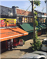
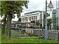
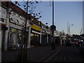
Shops, Norwood Road, Herne Hill, south London
Part of a long parade of shops opposite Brockwell Park Image and south of Herne Hill Station Image The railway runs behind these shops. Many roads converge and diverge in the area. Photographed from a No 3 bus (Whitehall-Crystal Palace: a great ride).
Image: © Robin Stott
Taken: 31 Jul 2020
0.08 miles
6
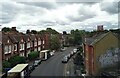
Croxted Road, West Dulwich, from the train
Croxted Road drops some fifty feet from the railway bridge down to Brockwell Park: the cyclist will be freewheeling.
Image: © Christopher Hilton
Taken: 2 Jun 2011
0.08 miles
7
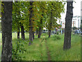
Through the trees, Brockwell Park
Trees along the park boundary with Norwood Road.
Image: © Robin Webster
Taken: 23 Jul 2011
0.08 miles
8
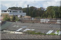
Graffiti on the frontage
Rooftops and frontage rears of shops on Norwood Road, Herne Hill see Image
Beyond is Brockwell Park.
Sorry this was taken from a moving train - wrist slapped!
Image: © David Lally
Taken: 10 Jun 2017
0.09 miles
9
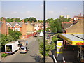
Shops on Norwood Road, Herne Hill
Looking south
Image: © David Howard
Taken: 3 Jan 2009
0.10 miles
10
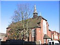
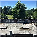
New Testament Church of God, West Dulwich
The church on Guernsey Grove was consecrated in 1912 as St John's (Church of England) but closed by 1962 and is now used by the New Testament Church of God and various community groups.
Image: © Stephen Craven
Taken: 21 Nov 2006
0.11 miles