IMAGES TAKEN NEAR TO
Brockwell Park Gardens, LONDON, SE24 9BJ
Introduction
This page details the photographs taken nearby to Brockwell Park Gardens, SE24 9BJ by members of the Geograph project.
The Geograph project started in 2005 with the aim of publishing, organising and preserving representative images for every square kilometre of Great Britain, Ireland and the Isle of Man.

There are currently over 7.5m images from over14,400 individuals and you can help contribute to the project by visiting https://www.geograph.org.uk
Image Map
Images are licensed for reuse under creativecommons.org/licenses/by-sa/2.0
Notes
- Clicking on the map will re-center to the selected point.
- The higher the marker number, the further away the image location is from the centre of the postcode.
Image Listing (89 Images Found)
Images are licensed for reuse under creativecommons.org/licenses/by-sa/2.0
Image
Details
Distance
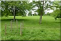
1
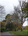
Brockwell Park (4)
Originally the grounds of Brockwell Hall, landscaped by J.B. Papworth, acquired from the Brockwell Estate by the London County Council in 1891, and later extended under the guiding hand of their Superintendent of Parks, Colonel J.J. Sexby, who added ponds, lakes, bandstand and walled garden. The park covers some 120 acres, including the popular lido. The hall now serves as the park's cafe (Image]).
Image: © Stephen Richards
Taken: 17 Nov 2012
0.03 miles
2
Brockwell Park (5)
Originally the grounds of Brockwell Hall, landscaped by J.B. Papworth, acquired from the Brockwell Estate by the London County Council in 1891, and later extended under the guiding hand of their Superintendent of Parks, Colonel J.J. Sexby, who added ponds, lakes, bandstand and walled garden. The park covers some 120 acres, including the popular lido. The hall now serves as the park's cafe (Image]).
Image: © Stephen Richards
Taken: 17 Nov 2012
0.04 miles
3
Brockwell Park (6)
Originally the grounds of Brockwell Hall, landscaped by J.B. Papworth, acquired from the Brockwell Estate by the London County Council in 1891, and later extended under the guiding hand of their Superintendent of Parks, Colonel J.J. Sexby, who added ponds, lakes, bandstand and walled garden. The park covers some 120 acres, including the popular lido. The hall now serves as the park's cafe (Image]).
The far houses are on Norwood Road.
Image: © Stephen Richards
Taken: 17 Nov 2012
0.06 miles
4
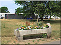
Drinking Trough in Brockwell Park
Just inside the park near one of the gate lodges. Good to see someone is watering the flowers as there is a drought and everything else is a bit parched.
There is an event in the park today and most of it is fenced off, as in the background here.
Image: © Des Blenkinsopp
Taken: 22 Jul 2018
0.06 miles
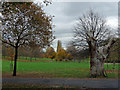
5
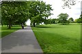
Park near Norwood Road
Looking across part of Brockwell Park from close to the Norwood Road entrance.
Image: © DS Pugh
Taken: 22 May 2016
0.07 miles
6
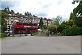
Norwood Road entrance
A London bus passes the entrance into Brockwell Park from Norwood Road.
Image: © DS Pugh
Taken: 22 May 2016
0.07 miles
7
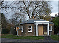
Norwood Lodge, Brockwell Park
Former lodge to the hall (Image]). Quite cute but the oversized portico is absurd. Was it moved from a larger building or has the lodge shrunk?
The park is currently subject to a fair amount of lottery-funded restoration and this is being done up with the intention of putting it to community use.
Image: © Stephen Richards
Taken: 17 Nov 2012
0.07 miles
8
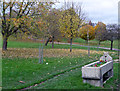
Cattle trough, Brockwell Park
A familiar Metropolitan Drinking Fountain and Cattle Trough Association job. I failed to get the date, but probably c1880.
Image: © Stephen Richards
Taken: 17 Nov 2012
0.08 miles
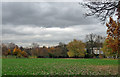
9
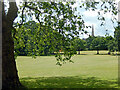
Path across Brockwell Park
Looking across part of Brockwell Park from the southern end of the park.
Image: © DS Pugh
Taken: 22 May 2016
0.08 miles
10
Brockwell Park
Looking across the southern part of the park with the spire of Holy Trinity Church, Tulse Hill, in the background.
Image: © Stephen McKay
Taken: 5 Jul 2023
0.09 miles