IMAGES TAKEN NEAR TO
Berwyn Road, LONDON, SE24 9BD
Introduction
This page details the photographs taken nearby to Berwyn Road, SE24 9BD by members of the Geograph project.
The Geograph project started in 2005 with the aim of publishing, organising and preserving representative images for every square kilometre of Great Britain, Ireland and the Isle of Man.

There are currently over 7.5m images from over14,400 individuals and you can help contribute to the project by visiting https://www.geograph.org.uk
Image Map
Images are licensed for reuse under creativecommons.org/licenses/by-sa/2.0
Notes
- Clicking on the map will re-center to the selected point.
- The higher the marker number, the further away the image location is from the centre of the postcode.
Image Listing (113 Images Found)
Images are licensed for reuse under creativecommons.org/licenses/by-sa/2.0
Image
Details
Distance
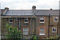
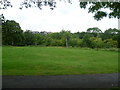
2
Tulse Hill
St.Faith's Road. At interesting variety of housing styles.
Image: © Peter Trimming
Taken: 8 Dec 2018
0.10 miles
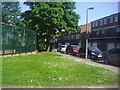
4
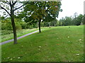
Walkway, Peabody Hill
In a housing estate built partly above Knight's Hill railway tunnel.
Image: © Robin Webster
Taken: 23 Jul 2011
0.13 miles
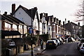
5
View from Knight's Hill
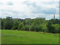
Knight's Hill remained undeveloped until the Peabody Trust extended their Rosendale Road estate during the 1970s by building a series of residential blocks on the very top. The land had long been owned by the Knight family, but was bought in sections by the American banker and philanthropist George Peabody during the late 19th century. The original estate was built at this time. The railway line between North Dulwich and Tulse Hill dating from 1868 passes through a tunnel under the hill. Knight's Hill is also sometimes known as Peabody Hill to avoid confusion with the Knights Hill at West Norwood. This view looks across to the spire of Holy Trinity Church on Trinity Rise.
Image: © Marathon
Taken: 31 Aug 2011
0.14 miles
6
Abbess Close, Tulse Hill
This is a private estate built around the early 70s.
Image: © David Howard
Taken: 27 May 2012
0.14 miles
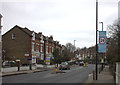
7
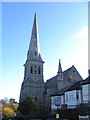
Holy Trinity Church, Tulse Hill
Anglican parish church on Trinity Rise. Built 1856 and Grade 2 listed.
Image: © Stephen Craven
Taken: 21 Nov 2006
0.14 miles
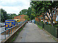
9
Small open space, Knight's Hill
The spire on the right is of Holy Trinity Church, Tulse Hill, on Trinity Rise.
Image: © Robin Webster
Taken: 23 Jul 2011
0.15 miles
10
On Knight's Hill
Knight's Hill remained undeveloped until the Peabody Trust extended their Rosendale Road estate during the 1970s by building a series of residential blocks on the very top. The land had long been owned by the Knight family, but was bought in sections by the American banker and philanthropist George Peabody during the late 19th century. The original estate was built at this time. The railway line between North Dulwich and Tulse Hill dating from 1868 passes through a tunnel under the hill. Knight's Hill is also sometimes known as Peabody Hill to avoid confusion with the Knights Hill at West Norwood.
Image: © Marathon
Taken: 31 Aug 2011
0.16 miles