IMAGES TAKEN NEAR TO
Norwood Road, LONDON, SE24 9AF
Introduction
This page details the photographs taken nearby to Norwood Road, SE24 9AF by members of the Geograph project.
The Geograph project started in 2005 with the aim of publishing, organising and preserving representative images for every square kilometre of Great Britain, Ireland and the Isle of Man.

There are currently over 7.5m images from over14,400 individuals and you can help contribute to the project by visiting https://www.geograph.org.uk
Image Map
Images are licensed for reuse under creativecommons.org/licenses/by-sa/2.0
Notes
- Clicking on the map will re-center to the selected point.
- The higher the marker number, the further away the image location is from the centre of the postcode.
Image Listing (74 Images Found)
Images are licensed for reuse under creativecommons.org/licenses/by-sa/2.0
Image
Details
Distance
1
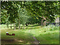
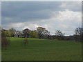
Unofficial park swing
The edge of Brockwell Park, with Norwood Road beyond the fence on the right.
Image: © Robin Webster
Taken: 23 Jul 2011
0.02 miles
3
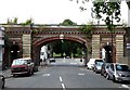
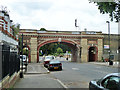
Railway bridge, Rosendale Road
This bridge, on the line between Herne Hill and Tulse Hill stations, dates from 1869 and is built of cream brick with red brick dressings. Grade II listed.
Pevsner singles out a number of the "unusually ornate" railway structures around Dulwich. They were designed by Charles Barry junior on behalf of the governors of Dulwich College.
Image: © Stephen Richards
Taken: 8 Aug 2009
0.06 miles
4
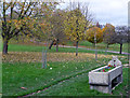
Cattle trough, Brockwell Park
A familiar Metropolitan Drinking Fountain and Cattle Trough Association job. I failed to get the date, but probably c1880.
Image: © Stephen Richards
Taken: 17 Nov 2012
0.07 miles
5
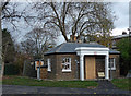
Norwood Lodge, Brockwell Park
Former lodge to the hall (Image]). Quite cute but the oversized portico is absurd. Was it moved from a larger building or has the lodge shrunk?
The park is currently subject to a fair amount of lottery-funded restoration and this is being done up with the intention of putting it to community use.
Image: © Stephen Richards
Taken: 17 Nov 2012
0.07 miles
6
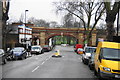
Railway bridge HHT 520
The Herne Hill - Tulse Hill line crosses Rosendale Road. A quite different style from the next bridge along, apart from featuring separate pedestrian passages - see Image
Image: © Robin Webster
Taken: 23 Jul 2011
0.07 miles
7
Ornate railway bridge on Rosendale Road
Several bridges on the same line have the same degree of attention. Beyond it is Brockwell Park.
Image: © Bill Boaden
Taken: 31 Jan 2014
0.07 miles
8
Brockwell Park (17)
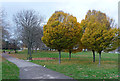
Originally the grounds of Brockwell Hall, landscaped by J.B. Papworth, acquired from the Brockwell Estate by the London County Council in 1891, and later extended under the guiding hand of their Superintendent of Parks, Colonel J.J. Sexby, who added ponds, lakes, bandstand and walled garden. The park covers some 120 acres, including the popular lido. The hall now serves as the park's cafe (Image]).
I think these four young trees with their beautifully compact, regular form are hornbeams. The path climbs up towards the hall.
Image: © Stephen Richards
Taken: 17 Nov 2012
0.08 miles
10
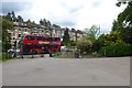
Norwood Road entrance
A London bus passes the entrance into Brockwell Park from Norwood Road.
Image: © DS Pugh
Taken: 22 May 2016
0.08 miles