IMAGES TAKEN NEAR TO
Shakespeare Road, LONDON, SE24 0LB
Introduction
This page details the photographs taken nearby to Shakespeare Road, SE24 0LB by members of the Geograph project.
The Geograph project started in 2005 with the aim of publishing, organising and preserving representative images for every square kilometre of Great Britain, Ireland and the Isle of Man.

There are currently over 7.5m images from over14,400 individuals and you can help contribute to the project by visiting https://www.geograph.org.uk
Image Map
Images are licensed for reuse under creativecommons.org/licenses/by-sa/2.0
Notes
- Clicking on the map will re-center to the selected point.
- The higher the marker number, the further away the image location is from the centre of the postcode.
Image Listing (95 Images Found)
Images are licensed for reuse under creativecommons.org/licenses/by-sa/2.0
Image
Details
Distance
1
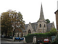
Former St Jude's church, Dulwich Road, Brockwell
This large church (seating over 1000 people) was designed by E.C.Robins, built by John Kirk of Woolwich and consecrated on 28 October 1868. Damaged by fire in 1923, and by bombing in 1940, it nevertheless was brought back into use. More detail at http://www.british-history.ac.uk/report.aspx?compid=43031#s6 . It is still shown as a church on the O.S. map, surprisingly, as it was declared redundant in 1979. It has since been a furniture warehouse and is now the home of Mark Allen Group (publishers).
Image: © Stephen Craven
Taken: 26 Aug 2008
0.08 miles
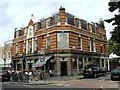
2
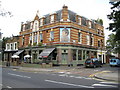
Herne Hill: The Prince Regent, Dulwich Road, SE24
There is a comprehensive architectural description of this fine Victorian pub, which is now a "gastropub", lifted directly, with due acknowledgement, from a London Borough of Lambeth document describing the proposed Poet's Corner Conservation Area as follows:
"The only public building within the proposed Conservation Area is a fine example of high Victorian pub architecture. "The Prince Regent" stands on a prominent corner site at the junction of Regent Street and Dulwich Road, the most southerly tip of the area. The facade has dramatic horizontal stripes of yellow stocks and red brick, broken by original sliding sash windows and brick pilasters. Built over three floors the top floor of the pub has a steep mansard roof with slate fish-scale hung tiles interspersed with striped brick dormer windows and a central stucco niche. In the niche stands the figure of the Prince Regent in ceremonial costume framed by a thick swath of stylised stucco vines and scrolls. Knotted ribbons of stucco fruit hang down below. The ground floor has pink granite pilasters and traditional large pub windows on both sides of the corner site. Although these large windows probably had etched glass originally the glass is now plain."
The pub's website is here http://theprinceregent.co.uk/
Image: © Nigel Cox
Taken: 11 Sep 2009
0.08 miles
4
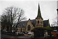
Former church on Dulwich Road
This was once St Jude's Church, but is now business premises.
Image: © Bill Boaden
Taken: 31 Jan 2014
0.09 miles
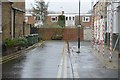
9

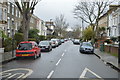
Dulwich Road
From the junction with Brixton Water Lane.
Image: © DS Pugh
Taken: 22 May 2016
0.10 miles
10
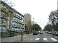
Zebra crossing on Dulwich Road, Herne Hill
Image: © David Howard
Taken: 24 Nov 2013
0.11 miles