IMAGES TAKEN NEAR TO
Milkwood Road, LONDON, SE24 0HX
Introduction
This page details the photographs taken nearby to Milkwood Road, SE24 0HX by members of the Geograph project.
The Geograph project started in 2005 with the aim of publishing, organising and preserving representative images for every square kilometre of Great Britain, Ireland and the Isle of Man.

There are currently over 7.5m images from over14,400 individuals and you can help contribute to the project by visiting https://www.geograph.org.uk
Image Map
Images are licensed for reuse under creativecommons.org/licenses/by-sa/2.0
Notes
- Clicking on the map will re-center to the selected point.
- The higher the marker number, the further away the image location is from the centre of the postcode.
Image Listing (55 Images Found)
Images are licensed for reuse under creativecommons.org/licenses/by-sa/2.0
Image
Details
Distance
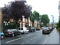
1
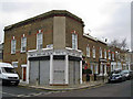
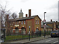
Davey's Unisex Hair Salon, Herne Hill
The building stands on the junction of Hinton Road and Alderton Road. It has the look of having once been a public house.
Image: © Richard Dorrell
Taken: 25 Dec 2011
0.05 miles
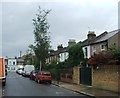
2
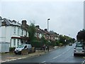
Flats and shops, Hinton Road
The ground floor of some of this parade of shops have been converted into flats. The location is Hinton Road, Brixton, looking south from close to its junction with Milkwood Road.
Image: © Richard Dorrell
Taken: 25 Dec 2011
0.07 miles
3
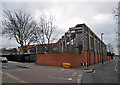
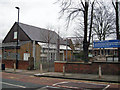
The Michael Tippett School, Lambeth
The Michael Tippett School was both the first Building Schools for the Future (BSF) school in London and the first Special Education Needs school to be built under the BSF programme. The school moved into this new building in Heron Road SE24 in February 2008. It provides 80 pupil places for students aged 11 to 18 who have profound and multiple special educational needs. The building was designed by London Eye architects, Marks Barfield, and built by Apollo Education.
The photo is taken from the junction between Heron Road (on the left) and Milkwood Road.
Image: © Richard Dorrell
Taken: 25 Dec 2011
0.08 miles
4

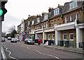
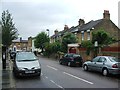
Petrol station, Brixton
The location is the junction of the B222, Milkwood Road and Hinton Road. The unusual lack of traffic and people is because the photograph is taken on Christmas Day morning.
Image: © Richard Dorrell
Taken: 25 Dec 2011
0.09 miles
8
St Saviour's Church of England Primary School, Herne Hill
This modern part of the school, and the playground, occupy land on which the former St Saviour's Church once stood. The church was declared redundant in 1973 and demolished in 1981. The school has just over 200 pupils, aged 5 to 11.
Image: © Richard Dorrell
Taken: 25 Dec 2011
0.12 miles
9
St Saviour's Church, Ruskin Park, Herne Hill
The building bears a carved inscription above the central arch declaring it to be St Saviour's Parish Hall, but a modern sign within the grounds proclaims that the building is now a Church of England church. The original St Saviour's Church (built 1867) stood a little to north of the Parish Hall. The site is now occupied by St Saviour's Primary School. The original church was demolished in 1981.
Image: © Richard Dorrell
Taken: 25 Dec 2011
0.13 miles