IMAGES TAKEN NEAR TO
Milkwood Road, LONDON, SE24 0EZ
Introduction
This page details the photographs taken nearby to Milkwood Road, SE24 0EZ by members of the Geograph project.
The Geograph project started in 2005 with the aim of publishing, organising and preserving representative images for every square kilometre of Great Britain, Ireland and the Isle of Man.

There are currently over 7.5m images from over14,400 individuals and you can help contribute to the project by visiting https://www.geograph.org.uk
Image Map
Images are licensed for reuse under creativecommons.org/licenses/by-sa/2.0
Notes
- Clicking on the map will re-center to the selected point.
- The higher the marker number, the further away the image location is from the centre of the postcode.
Image Listing (169 Images Found)
Images are licensed for reuse under creativecommons.org/licenses/by-sa/2.0
Image
Details
Distance
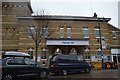
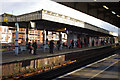
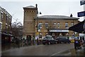
3
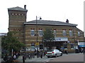
Herne Hill station
The railway station building at Herne Hill, South London.
Image: © Malc McDonald
Taken: 30 May 2011
0.01 miles
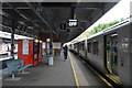
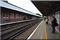
6
Herne Hill station
The station building at Herne Hill, in South London.
Image: © Malc McDonald
Taken: 30 May 2011
0.02 miles
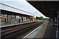
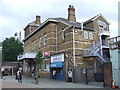
9
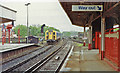
Out into SE London and Kent from Herne Hill station, 1992
View SE from the country end of the Up Main platform, with a Chatham main line train leaving towards Sydenham Hill, Bromley South etc. For further detail see Image
Image: © Ben Brooksbank
Taken: 2 May 1992
0.02 miles